

This post is adapted from my book, King Alfred: A Man on the Move, available from Amazon. It would be great if you could support this project by purchasing a copy.

Alfred had seen to it that the Vikings would leave Exeter and the whole of Wessex in 877. However, they would return to Wessex and take Chippenham early in 878. This set off a chain of events that would eventually lead to the important Wessex victory over the Vikings at the Battle of Ethandun.
The arrival of the Vikings at Chippenham was an important turning point because the Anglo-Saxon Chronicles tell us that the Vikings then over-ran Wessex, and It was at this point that Alfred went into hiding. It is worth pausing to reflect on what the Chronicle tells us, which is that the Vikings did not just over-run the area around Chippenham, but probably at least most of Wessex, and all of Wessex if we take it literally. There were clearly parts of Wessex that were beyond their control, such as the area in north Devon where the Battle of Cynuit took place, and Athelney, where Alfred found a safe haven for a while. But the implication is still that, for a short while in 878dc, Wessex had been lost to the Vikings. As Wessex was the last kingdom in what we now call England still independent of Viking rule, this also means that for a short while in 878, between Twelfth Night and some time after Easter, the Vikings had control over the whole of England. With King Alfred on the run they must have seen a permanent victory as a plausible outcome.
It is important to appreciate that Alfred decided to stay and did not flee to, for example, Rome. When Mercia had collapsed under the Vikings in 874, the ruler, King Burghred, fled to Rome. Circumstances would not have been precisely the same, they never are, but I believe things would have turned out very differently had Alfred fled. But he did not. From a position that must have seemed irrecoverable to many he fought and won back his kingdom and, eventually, during the reign of his grandson, Athelstan, all of England would be recovered from Viking rule.
It has been suggested that King Alfred had spent Twelfth Night, in January of 878 at Chippenham. However, I can find no evidence that this was the case. However, it is undoubtedly possible as Chippenham was a royal estate, and it would have provided a reason for the Vikings to arrive there at this particular time. Chippenham seems to have been important as Asser recorded that this had been the location of Alfred’s sister’s marriage to Burghred, King of Mercia in 853. However, Alfred may not have been present at his sister’s wedding as Asser also records that in the same year the young Alfred had gone to Rome, with no indication as to when he returned, although it must have been before 855, as Asser says that Alfred went with his father a second time to Rome in that year (but with the Anglo-Saxon Chronicle only mentioning his father going).

Chippenham enters the story again, still in 878, immediately after Alfred won the Battle of Ethandun, for it is recorded in the Anglo-Saxon Chronicle that when Alfred put the Vikings to flight, he pursued them as far as an unnamed fortification (geweorc). It has been suggested that this location was perhaps Chippenham. This seems plausible in relation to the most likely sites for the battle. The Anglo-Saxon Chronicle also tells us that the Vikings moved from Chippenham to Cirencester after Guthrum’s baptism. Chippenham seems to have served as a Viking base. It is unlikely that the unnamed fortification was Bratton Camp, on the north-west edge of Salisbury Plain, as provisions for troops and animals would have been difficult to provide on this elevated landscape over an extended period.
The Anglo-Saxon Chronicle tells us that after the Battle of Ethandun Alfred put this fortification under siege for fourteen days, after which the Vikings surrendered. Asser provides further detail and identifies the location of Alfred’s besieging camp as being in front of the gates of the Viking fortification.
Asser indicates that the location that the Vikings took at Chippenham prior to the Battle of Ethandun as being on the eastern bank of the Avon. It seems likely that any fortification at Chippenham that the Vikings retreated to after Ethandun would be at this same location. Examination of a map shows that there is a bend in the Avon that would allow the Vikings to defend a peninsula, similar to their tactic at Reading. This is where the old town is located. I parked in the Sadler’s Mead car park and walked down to the River Avon, being the same river that flows through Bath and emerges at Avonmouth near Bristol. I walked along the path that heads west and then south along the outer bank, allowing me to appreciate what may have constituted Asser’s east bank of the Avon.
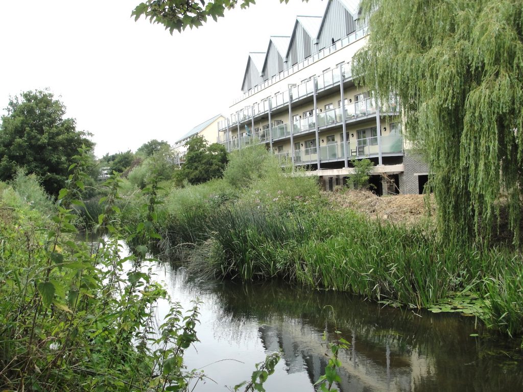
It is important to note that the river today is not the same as it appears on old maps, and It would have been even more different in the time of Alfred. But even going back to the Ordnance Survey map of 1886, one can see an Isle of Rea, which no longer exists as such, just south of the town bridge (High Street). My impression is that this island is where much of the deeply unaesthetic Borough Parade shopping centre now stands. This area can therefore be excluded from being Asser’s east of the Avon. Just south of here the river once divided again into a main stream and a Hardenhuish Brook, forming yet another island called The Ham. However, it seems like it is the brook rather than the main stream that has disappeared so that when we look across the river at this point today we are looking at the east bank of the Avon as opposed to the eastern edge of a former island. So I proceeded to walk all the way down the western bank looking across at the eastern bank. Nowadays, perhaps unsurprisingly, this area has been developed, except at the point where one reaches some playing fields.

So does this help locate the Viking fortress? It could have been anywhere along this stretch of the east bank as it runs through Chippenham, whilst allowing for the disappearance of the Isle of Rea. However, another option arises. Because the Avon bends sharply, there is a second eastern bank a little further east. A Monkton House is located here, and this is on the location of an older manor house. However, I feel that this is a less likely location because of the pattern of the Vikings usage of water to defend themselves on three sides, which the latter site could not provide. But there is also a third option. Neither Asser nor the Chronicle states whether the Vikings set up their own fortress or took over what was already there instead. Asser records that Chippenham was a royal estate and I believe it would therefore have had some defences, particularly bearing in mind its northerly location compared to the rest of Wessex. It seems to me inconceivable that the Vikings would drive the Saxons out of Chippenham and not use the Saxon site as a base. Establishing the location of the royal estate may therefore also be helpful, as this could be the same location as the Viking fortress. St Andrew’s church is near the Market Place (the main focus of the Saxon town) and St Andrew’s has been described as probably the site of the Saxon church. Ordnance Survey maps from 1900 to 1967 indicate a “site of King Arthur’s Palace” between the Market Place and Gladstone Road. Although it is named after King Arthur, who we cannot prove existed, one wonders how this royal connotation came about. The area indicated is to the rear of the current Museum and Heritage Centre and also appears to be at the northern end of a restricted parking area accessed off Timber Street. The access is opposite to where I found a very good Caribbean restaurant where I enjoyed the best jerk chicken I have ever tasted.
Anybody who walks down St Mary’s Street will sense it’s age and indeed it is considered to be part of the Saxon settlement, with the area to the north of St Andrew’s chuch considered to be a possibility for the location of the royal estate. Therefore we have two potential sites for a royal palace, one to the west of The Causeway and one to the east. Both of these of course meet Asser’s description of being east of the Avon. However, the latter site would probably be better described as being west of the Avon as it is closer to the other side of the peninsula. It is also possible that the royal site ranged across both of these locations and perhaps we should not always consider them as separate.

For me, therefore, the most likely location for both the Royal Estate and the Viking fortification extends between Borough Parade shopping centre car park in the north, Timber Street in the south, and St Mary’s Street to the east. This would be east of the Avon, yet far enough up the peninsula to make that a defensive feature.
There is much more about the travels of King Alfred in my book, including maps and references. To learn more about the book, click or tap the image below: