King Alfred and Surrey: Exploring a ‘hotspot.”

This post is adapted from my book, King Alfred: A Man on the Move, available from Amazon. It would be great if you could support this project by purchasing a copy.

I was contacted by somebody who noticed that there was a window depicting King Alfred in a church at Busbridge, not far from Godalming in Surrey. At first I thought that this window was just a random dedication to King Alfred, perhaps associated with the celebration of the 1000th anniversary of his death in 1901 (back then they thought he had died in 901 instead of what it is now know to be, which is 899). However, this for me set off a chain of events that led to me exploring Eashing, Godalming and Guildford. Each place was already significant to me in its own right, but there was no record of Alfred having been at any of them. However, when I looked at these places collectively it seemed to me unlikely that he would never have been at any of these places. Let me explain.

King Alfred stained glass window at St John the Baptist church, Busbridge, near Godalming, Surrey
From the same stained glass window. This shows the now lost church at Tuesley, Surrey, and the well to the left has become Ladywell Convent
From the same stained glass window. This shows the now lost church at Tuesley, Surrey, and the well to the left has become Ladywell Convent.

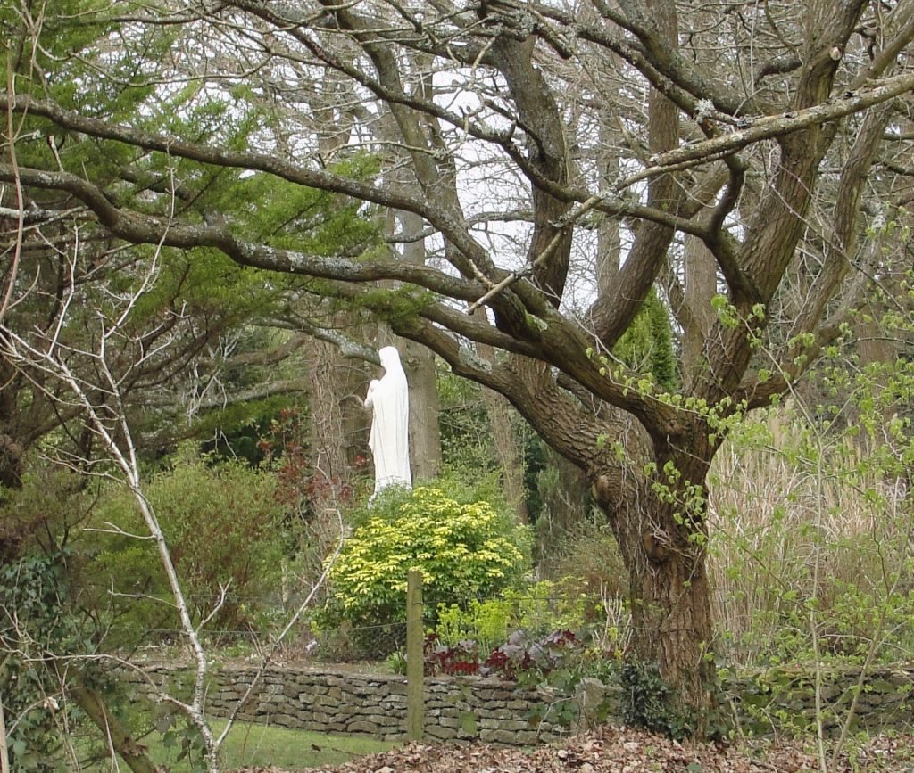
King Alfred’s will includes estates at Guildford, Godalming and Eashing, and the Burghal Hidage (a list of Alfred’s defended settlements after 878, but drawn up under his son, King Edward the Elder) includes Eashing.  These three locations are close together and are all on the River Wey, which flows into the Thames. Alfred’s connection to the area is remembered in a beautiful stained-glass window in the already mentioned Victorian church of St John the Baptist in Busbridge,  just a couple of miles south of Godalming (there are other stunning windows in this church). He is depicted above an image in the same window of a Saxon church at a place called Tuesley. Tuesley, just to the south-west of Busbridge, is the site of this now lost 7th century Saxon church, and it may be that there was a site of worship here going back to pagan times. It seems that Tuesley derives from the name of the pagan god Tiw , from which we also get “Tuesday”. It has been suggested that the settlement at Tuesley was a predecessor to the settlement at Godalming although, as Tuesley is mentioned in the 1068 Domesday book, the settlement would still have been present in Alfred’s time.  The location of this church is now a shrine to the Virgin Mary and is on land now owned by Ladywell Convent. At the time of writing there is access to this location every day except 21st December. It is a peaceful and beautiful site and I highly recommend spending some time there. We know that Alfred was pious and if he was in this area I think he would have come to this significant church. The shrine is on the other side of the road to the convent, and the access is through a gate down a very short track.

The shrine of the Virgin Mary inside a wall depicting the outline of the old Saxon church at Tuesley, Surrey. I have read that this church had been dedicated to the Virgin Mary
The shrine of the Virgin Mary inside a wall depicting the outline of the old Saxon church at Tuesley, Surrey. I have read that this church had been dedicated to the Virgin Mary.

In Godalming there is good evidence that a church on the current site of the church of St Peter and St Paul would have been present in the 9th century , while King Alfred was alive, and it seems plausible that the church would have been associated with the royal estate there. The royal estate may therefore have been in this part of Godalming, potentially around Church Street, to the south of the church. I was told that an archaeological investigation was carried out before some new buildings were built to the south-west of the church and that hundreds of Anglo-Saxon skeletons had been discovered. However, when I visited Godalming’s museum (with its excellent and helpful staff) I found out that more mid to late-Saxon pottery had been found at the site of what is now Waitrose on Bridge Street, than anywhere else in Surrey and it was now thought that the “Royal Manor” could have been at this location instead, which is quite a distance from the church. However, it seems impossible to tell whether particular estates that Alfred left in his will comprised the whole of that named place or just a part of it. In other words, he might have left the whole of Godalming because he owned all of it. In this situation, looking for a separate “Royal Manor” would be a mistake.

Church of St Peter and St Paul, Godalming, Surrey

We cannot be certain of the location of the royal estate at Guildford but it seems most likely that it would have been located where evidence suggests there was a Saxon presence.  Indeed, following the argument applied to Godalming, he may have owned all of what comprised Guildford at that time.It appears that the Saxon settlement at this time would have been in the area around St Mary’s church. There is evidence that this church may have been preceded by a timber structure. I was very grateful for the assistance given to me in my research by this church and a local historian, and I thank them here. I found it pleasant to wander around this area,which is essentially around Quarry Street. The remains of Guildford’s Norman castle are also in this area. 

St Mary's Church and Quarry Street, Guildford, Surrey
St Mary’s Church and Quarry Street, Guildford, Surrey

The main contender for the the fortified site at Eashing  is immediately to the east of the famous Eashing Bridges, which are marked on Ordnance Survey maps.  There is no public access across the site although a combination of roads and footpaths delineate the perimeter. It may be significant that this site would have been able to defended a crossing over the River Wey at the site of the Eashing Bridges. Today, the location is largely open space, and it is thought that this is because Guildford replaced it as the regional centre.

Paul Kelly. Author of King Alfred: A Man on the Move, at Eashing burgh, Surrey.
The author at the site of the burgh of Eashing, Surrey

The two sides that have a footpath are easy to find. I parked at the little car park on the other side of the historic bridges,walked across and then up the path leading uphill on the west side. From here I could really appreciate how the burgh would have been in an elevated position above the River Wey. But I could only see the (likely) site of the burgh when I got to the path that runs across the north of the site. It was just an open field, but I found that I could use my imagination. I decided not to follow the road for the two remaining sides of the square as it looked dangerous, with no footpath.

I made a short video about these locations:

There is much more about the travels of King Alfred in my book, including maps and references. To learn more about the book, click or tap the image below.

The River Fleet. Dividing the two London Saxon settlements.

This post provides additional material in relation to my book: King Alfred, a Man on the Move, available from Amazon and bookshops.

It is known that prior to the time of King Alfred the Saxon community in London had largely moved out of the old Roman walled city and had moved to the area that we now know as Aldwych and Covent Garden. After about 886, when King Alfred is said to have restored London, the main settlement became once again within the Roman walls. It seems clear that for a period of time there would have been two communities. In King Alfred’s time the two communities would have been separated by the River Fleet, which presumably would have been bridged at some point. It is important to note that this was not a small river. This is easy to forget now that it’s flow is subterranean in sewers. However, there are clues from the landscape and from history for those who look for them. In this post I only look at the course through central London, as this is the most relevant to establishing what made London at the time of King Alfred. The sources for the river are the springs feeding the ponds that are on the high ground at Hampstead and at Highgate. I pick up the route at Old St Pancras Church, which is to the west side of the tracks coming out of St Pancras International train station. I will place a video at the end, which picks up the route a little further on at King’s Cross Road. Things are complicated by there being three routes: one being the course of the lost river,  another being the canalised sewer that now holds the flow, and yet another being an overflow. My priority was the course of the river itself.

St Pancras Road, London, looking south. On the left is Old St Pancras Church and straight ahead is St Pancras International train station. A yellow line gives a broad indication of the former course of the River Fleet.
St Pancras Rd, London, looking south. On the left is Old St Pancras Church and straight ahead is St Pancras International train station. The yellow line gives a broad indication of the former course of the River Fleet.

The river ran to the west of St Pancras Old Church and its course then runs under St Pancras Train Station to then reappear on the other side where it explains the curve in the Great Northern Hotel.

Looking north from Euston Road, London. St Pancras train station is on the left, King's Cross train station is out of shot on the right, and the Great Northern Hotel is visible on the right. An arrow shows the approximate former course of the River Fleet. The arrow follows the curve of the Great Northern Hotel.
Looking north from Euston Road, London. St Pancras train station is on the left, King’s Cross train station is out of shot on the right, and the Great Northern Hotel is visible on the right. The arrow shows the approximate former course of the River Fleet. The arrow is attempting to follow the curve of the Great Northern Hotel.

From there the route goes a short way down Pentonville Road until King’s Cross Road branches off, which it then follows.

After King's Cross train station, the course of the River Fleet heads down Pentonville Road until it meets with King's Cross Road. This photo shows which road is Pentonville Road, and therefore the former course of the river must head in this direction. The photo is taken looking east, with King's Cross just visible on the left.
After King’s Cross train station, the course of the River Fleet heads down Pentonville Road until it meets with King’s Cross Road. This photo shows which road is Pentonville Road, and therefore the former course of the river must head in this direction. The photo is taken looking east, with King’s Cross just visible on the left.
Looking east and showing the junction of Pentonville Road with King's Cross Road, which the course of the River Fleet then follows.
Looking east and showing the junction of Pentonville Road with King’s Cross Road, which the course of the River Fleet then follows.

Things get a bit trickier when one arrives at Cubitt Street as the river then ceases to follow King’s Cross Road but bends to the west instead. It is tricky to follow the exact route here (you will see the confusion in my video!), but its route can be picked up again in Mount Pleasant (near the Royal Mail sorting office, built on the site of Coldbath prison) from where it runs down Warner Street and Ray Street until it joins Farringdon Road.

At Mount Pleasant, looking west. The dip in the road, where the River Fleet would have flowed, can be clearly seen.
At Mount Pleasant, looking east. Again, the dip in the road where the River Fleet would have flowed can be clearly seen.

I was told that outside the Coach pub and restaurant (previously Coach and Horses pub) one could hear the waters of the Fleet through a grill. I am very pleased to say that this was the case, although this of course is not the actual river but the canalised flow. It did sound quite healthy though.

A grill in the road where the flow of the River Fleet can be heard.
This photo should help you find the correct grill

Once you have reached Farringdon Road the course is much simpler to follow as it follows Farringdon Road, then Farringdon Street, then New Bridge Street down to where it flowed into the Thames where Blackfriars Bridge is today. There are some great places to see how the river flowed through here by looking at the landscape. My favourite is to walk up towards Smithfield Market (up Charterhouse Street) and look back. It is very easy to see the dip in which the river once flowed.

On Charterhouse Street, London, looking west. If you look carefully you can see that the roads runs downhill and then rises again after the yellow arrow. A yellow arrow shows the former line of the River Fleet running down into Farringdon Street.
On Charterhouse Street, London, looking west. If you look carefully you can see that the roads runs downhill and then rises again after the yellow arrow. The yellow arrow shows the former line of the River Fleet running down into Farringdon Street.

As you head closer to the Thames you pass Ludgate Circus, which would have in the past been the site of an important bridge across the Fleet. Whether there was a bridge here in Saxon times is not known.  On the right as you proceed further you will pass the site of Henry the VIII’s palace called the Bridewell. It is amazing to think that Henry VIII had a waterfront palace on this lost waterway. This later became another prison.

I understand that the flow into the Thames can be seen, but it seemed to me that the position from which one could view this was obstructed by construction work when I visited.

Near the end of the route there is a pub called the Black Friar, which I thoroughly recommend for a break.

You can watch the video below. My book, King Alfred: a Man on the Move, is available on Amazon.