King Alfred and Wimborne, Dorset. Did he become King of Wessex here?

Wimborne Minster, Dorset

The following article on King Alfred and Wimborne is adapted from, and provides additional materials for, my book, King Alfred: A Man on the Move, available from Amazon It would be great if you could support this project by purchasing a copy.

Death of Æthelred

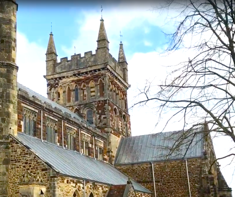
Wimborne (or Wimborne Minster) is a significant historic town in Dorset and is the location of the important Wimborne Minster, which has a history going back to the 8th century. Most versions of the Anglo-Saxon Chronicles tell us that after the 871 AD battle at Meretun (unknown location, but possibly Martin in Hampshire) King Æthelred, Alfred’s older brother, was buried at Wimborne. However, one version of the Anglo-Saxon Chronicles tells us that he was buried at Sherborne, which seems plausible as the two previous kings and brothers of Alfred, Æthelbald and Æthelbehrt, had been buried there. I consider it possible that Æthelred was initially interred at Wimborne, and then later moved to Sherborne, probably because of the relative importance of the latter location. It is further recorded that Alfred had been present at his brother’s funeral rites, which is what we would expect.

The plaque inside Wimborne Minster, Dorset, dedicated to King Ethelred.
The plaque inside Wimborne Minster, Dorset, dedicated to King Æthelred. Incidentally, there is no evidence that he was killed in battle. The Anglo-Saxon Chronicles indicate that he died some time afterwards. The keen-eyed will note that the upper portion of Æthelred’s sceptre has been broken off.

Alfred becomes King

We know that Alfred himself became king after the death of King Æthelred, although the location where this formally took place has not been recorded. I suggest, however, that there is a good chance that Alfred became king at Wimborne, particularly if he had already been designated as next in line, which Asser tells us was the case. Alfred’s immediate elevation on the death of his brother also makes sense in the context of the kingship having run sequentially through Æthelwulf’s sons up to that point. Asser points out a couple of times that Alfred had been what he calls secundarius and that he took over immediately (confestim) on the death of his brother. It should be borne in mind, however, that just because we are told that Æthelred had been buried at Wimborne does not mean that he died there, with this meaning that Alfred could have become king somewhere else. Nonetheless, Wimborne seems plausible because we know that it had significance because the royal estate there was seized in 899 by Æthelwold after Alfred’s death (if it was significant in 899 it seems likely that had been so in 871).

The tower of Wimborne Minster, Dorset

The battles that took place in 871 indicate that Wessex was clearly in a state of emergency at the time King Æthelred died, and perhaps the formal ceremonial arrangements of Alfred’s accession were delayed until the relatively peaceful period between 872 and 874 when the Vikings that had been at Reading were causing trouble in Mercia and Northumbria instead. If there was ever a formal ceremony, we have no evidence of it. It has been suggested that Alfred became king in Winchester, but I have seen no evidence of this. Furthermore, it appears that Kingston-upon-Thames had not yet become (as it would) the favoured site for the consecration of the Anglo-Saxon kings.

Map of Wimborne, Dorset. Mudge 1811
Map of Wimborne, Dorset. Detail from an 1811 map by Mudge
Map of Wimborne Dorset. Hutchins.
Map of Wimborne, Dorset (detail), showing the area around the minster. From Hutchins 3rd Edition (1870)

The relationship between King Alfred and Wimborne is an interesting one.

There is much more about the travels of King Alfred in my book, including maps and references. Tap or click the image to learn more.

Update on the plaque in Wimborne Minster.

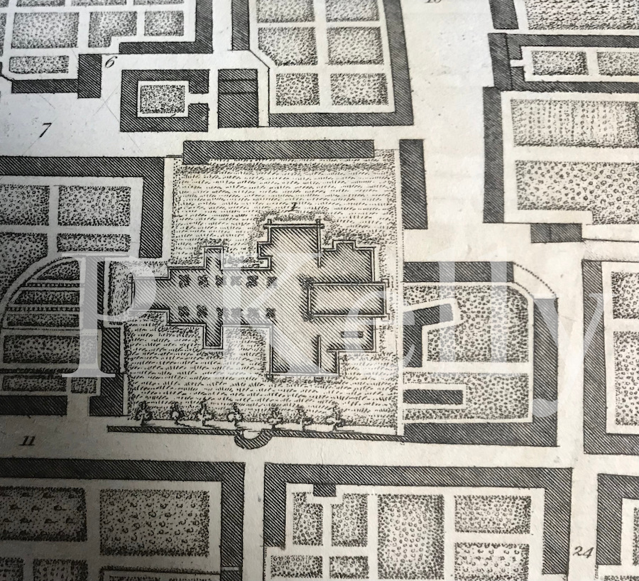
I came across some articles of the Dorset Natural History and Antiquarian Field Club, which shed further light on the plaque (or, more correctly, plaques. The 1918 contribution by Reverend Almack reminds us that restoration took place 1855-7. he goes on to tell us that the slab that had been over the remains of King Æthelred “was cut away, in spite of protest, and only the portion sufficient to cover the brass was allowed to remain.” We are also told that during restoration the remains of a tesselated pavement and the bases of columns were observed, which has led to speculation that the first church here was built over a Roman temple. However, the authors of the Royal Commission on Historic Monuments suggests that this may have been from the original church of St Cuthburh.

This monument was clearly a hot topic as in the 1919 issue there is a long article by Reverend Fletcher, which he had read out in 1918. In this he states that the plaque(s) were “placed in the floor on the north side of the sanctuary at Wimborne Minster, about 15 ft from the east wall, and consists of three metal plates.” Of course, today, the plaques are on the wall and not on the floor. The author reminds us that brasses were not used in England until about the 13th century, although this one may be more recent, possibly 15th century. Therefore, the brass cannot be contemporaneous with the death of Æthelred. Furthermore, the author points out that the section with script is even more recent and is copper not brass. This second inscription plate was found to be a palimpsest and may be 18th century (Dorset Natural History and Antiquarian Field Club Proceedings 1919, p32)

So, where are King Æthelred’s remains? Unless there is a huge coincidence, we can be sure that they are not where the plaque is, because it has been moved at least once, and is not contemporaneous with his death in any case. It is possible, however, that when the brass sections were made they were placed at the (at least claimed) location of his remains, which would have been within the footprint of the Saxon church and probably near the altar. This would have been just to the east of the crossing, which seems to have stayed in the same place over time (RCHM. Dorset. Vol V; East). It needs to be recalled, however, that he may have been moved to Sherborne. If he had been moved to Sherborne, there was still a record of him by Leland in 1536 at Wimborne.

Leland describes the text on the plaque, which is the same as we have now except for a different (and obviously wrong) date. Camden, writing in 1586, tells us that the tomb had been recently repaired, so it is possible that the date was corrected then and that the text part of the plaque that we have now dates to that time. Or perhaps Camden just wrote the wrong date down and the plaque did not need correction at the time of the repair. Leland also tells us that by 1828 Æthelred’s tomb had been by that of St Cuthberga, which was at the north side of the Presbytery (chancel). He goes on to tell us that St Cuthberga was then moved to the east end of the altar. St Cuthberga is hugely important to this church, but I will have to go into that further elsewhere, time permitting.

Things are further complicated by the finding (as reported by a Dr Smart in The Genetleman’s Magazine, 1865) that when enlarging a vault under the presbytery in 1837, a skeleton of a man was exhumed at the north east corner, near the site of the original altar. This man was 6ft 4 ins tall. Could this have been Æthelred? It certainly seems a suitable location. This same source includes a suggestion that Æthelred died of his wounds at Witchampton (north of Wimborne), based on this being a similar name to “Whittingham”, a place mentioned by earlier writers, such as Camden. However, we don’t know where Camden got this from and, in any case, Witchampton does not seem to connect with the name Whittingham (Mills, Place Names of Dorset. Part 2). Witchampton as a legendary place of death of Æthelred is again mentioned in A Topography of Alfred’s Wars in Wessex, by Williams-Freeman. However, I haven’t come across anything to support this other than that Witchampton is on a plausible route between Martin and Wimborne. Nonetheless, a portable information board in the church at Witchampton states: “The old records say his funeral procession came through Witchampton, where the bier rested on its way to Wimborne. Among the mourners was his brother who later became King Alfred the Great.” Unfortunately, we are again not told what these “old records” are. Witchampton was also the location of the discovery of late Saxon chess pieces.

A King Sigferth was also buried at Wimborne, in AD 962. This is a mysterious character who we know very little about, including what he was king of. The entry in the Anglo Saxon Chronicles is generally translated that he committed suicide. I am uncertain whether he would have been allowed to have been buried in the church if that was the case. Much rests on the meaning of offeoll in “Sigferð cyning hine offeoll“.

It is fascinating to think that Wimborne Minster once had a spire, which fell in 1600.

Wessex – where was it?

This post is aimed at answering one of the most common questions that I am asked. I live in a county (Dorset) for which the regional National Health Service is designated “Wessex”, and a local radio station is called Wessex FM. People tend to know that they are in Wessex (probably) but are uncertain of the area it should be thought to cover. I wish that the answer that I am called upon to provide was more straight-forward.

As this blog is based on King Alfred, I shall describe what Wessex was in that time period. As King Alfred is often associated with Wessex, this will hopefully answer the question for most people. Alfred was King of Wessex from 871 to 899. The following is adapted from my book, King Alfred: A Man on the Move, which is available from Amazon. It would be great if you could support this project by purchasing the book.

In King Alfred’s time, Wessex included the counties that we now call Devon, Dorset, Somerset, Wiltshire, Berkshire (and some of adjacent Oxfordshire), Hampshire, the Isle of Wight, East and West Sussex, Kent and Surrey. Also included was Essex until it was ceded to Guthrum the Viking in a treaty drawn up around the year 886. It is worth pointing out that there were additional areas where King Alfred seems to have had the upper hand in power-sharing arrangements. By the end of his reign, this included London, which had earlier been under Mercian control. It also seems from Asser’s writings that at some time before 893 South Wales came under King Alfred’s control. Nor must we forget Mercia itself. After about 879, western and southern Mercia (eastern Mercia remained under Viking control) was ruled by Æthelred, who was the son-in-law of King Alfred, and it seems that it was Alfred who had the upper hand.

A  map of Wessex. A schematic diagram of territorial divisions at the start of King Alfred's reign.
A map of Wessex from my book. A schematic diagram of territorial divisions at the start of King Alfred’s reign. Contains OS data © Crown copyright and database right (2018).

The extent of Wessex control in Cornwall is still unclear. The Annales Cambriæ tell us that King Dungarth of Cornwall drowned in 875, but after that there is no mention of who was ruling in Cornwall until 926 where a version of the Anglo-Saxon Chronicles mentions a King Huwal of West Wales, which would have then meant Cornwall. It therefore seems to me that from a monarchical point of view Cornwall remained independent during Alfred’s time. However, we know that the diocese of Sherborne (in Dorset and therefore in Wessex) extended across the whole of Cornwall.

I did say earlier that it was not straight forward. But perhaps this post will lead to a better understanding. Tap or click the image to learn more about the book.

History of Dorchester: King Alfred

This post looks at King Alfred in the history of Dorchester (Dorset), and is adapted from, and provides additional materials for, my book , King Alfred: A Man on the Move, available from Amazon and book shops.

I have lived near Dorchester for many years. Evidence from charters (legal documents showing transfers of land or rights) indicates that Alfred came to Dorchester while his elder brother Æthelred was king, and therefore presumably there would have been some sort of Saxon base there. Links to transcripts of these charters are here and here. Please note that very few charters have not been challenged as to their authenticity, either in whole or in part.

The line of the west wall of Dorchester. Towards Salisbury Street.
The line of the west wall of Dorchester, looking north towards Salisbury Street.

Where was the royal residence?

Clues about the Saxon history of Dorchester are scant, and this includes any evidence that might help us establish the location of a Saxon royal residence at the time of King Alfred. My personal speculation, which I have heard others suggest as well, is that the royal site would have included the location on the northern edge of the town where the current prison buildings are sited, where we know that the Norman castle was also located. It seems to make sense that if a site was deemed defendable by the Saxons (which a royal site would need to be) then it would hold a similar appeal for the Normans. It therefore seems plausible that the Normans would have built their castle on the site of the previous Saxon fortification/royal residence. There is a very pleasant footpath that follows the River Frome and which passes below the site of the former castle. From there one can understand how elevated (and therefore defendable) the site would have been.

Dorchester prison. Site of Norman castle. Probable Saxon stronghold or royal location.
Dorchester prison, now being converted to residences, is on the site of the Norman castle, and possibly also the Saxon stronghold/royal location.

Map of Dorchester, Dorset
Map of Dorchester Dorset, presented to Mayor Kingston. From Hutchins. Research suggests this ultimately derives from 1771.

Fordington

It has been suggested that King Alfred spent every Christmas at a royal manor at Fordington, which is now part of Dorchester but was once a separate settlement, not only to the east, but also around the south and to the west (where it was called West Fordington). I have found nothing to support the claim that there was a Christmas residence of the Wessex court in or near Dorchester. The oldest reference I could find referring to this was in Beatrice Adelaide Lees’ 1915 book on King Alfred where she states “…there is nothing to show that he was in North Wiltshire at the time of the inroad, and the Dorset Dorchester, which was a more usual place for the Christmas sojourn of the West-Saxon court…”. However, she does not indicate where she gets this information from. The Viking attack of Chippenham of 878 is being referred to.

It has been suggested that King Alfred spent every Christmas at a royal manor at Fordington, which is now part of Dorchester but was once a separate settlement, not only to the east, but also around the south and to the west (where it was called West Fordington). I have found nothing to support the claim that there was a Christmas residence of the Wessex court in or near Dorchester. The oldest reference I could find referring to this was in Beatrice Adelaide Lees’ 1915 book on King Alfred where she states “…there is nothing to show that he was in North Wiltshire at the time of the inroad, and the Dorset Dorchester, which was a more usual place for the Christmas sojourn of the West-Saxon court…”. However, she does not indicate where she gets this information from. The Viking attack of Chippenham of 878 is being referred to.

 I have also read that Fordington became a royal manor after the Romans left and that the first church there had been built about 857, and that this was a royal church dedicated to St George. Although the earliest parts of the current St George’s church date to the 11th century, it is located at the site of a Roman cemetery so the location was clearly a significant one stretching back to ancient times, which makes the presence of a church being there in 857 seem more plausible.

Roman gravestone St George's Church, Fordington, Dorchester, Dorset
The Roman gravestone that is to be found inside St George’s Church, Fordington. An explanatory plaque tells us that it was found in 1907 as a foundation stone beneath the Norman porch.

It is thought that burials found at the site of what is now the Trumpet Major pub were Saxon (although earlier than the time of King Alfred) (DNHAS Proceedings 1984)

St George's church, Fordington, Dorchester. Dorset
St George’s church, Fordington, Dorchester (Dorset)

So, we have two potential royal locations that are close to each other, one in the centre of Dorchester at the site of the former prison, and the other at Fordington. Although the evidence from charters suggests that Dorchester really was a royal location, I am not aware of any charters having been issued from Fordington. It is perhaps possible that a royal residence at Fordington would have been close enough to Dorchester to go under that name, or that the residence was at Fordington while the charters were signed at nearby Dorchester. Fordington is so close to Dorchester that I found that I could walk, at a brisk pace, from St George’s church in Fordington to the closest point of Dorchester’s former Roman walls in a matter of three minutes.

St George's Fordington
This image of Fordington is from Richard Grosvenor Bartelot’s History of Fordington (1915). St George’s church is shown. The position from which it was drawn is somewhat difficult to determine, but I think it might have been somewhere near the junction of High Street Fordington and Pound Lane.
St George's Church, Fordington, Dorchester
View of St George’s Church, Fordington from the north west, where the farm was once located. From Richard Grosvenor Bartelot’s History of Fordington (1915).

Dorchester’s walls

It seems to me that the Roman walls (perhaps replaced or repaired in places) would have been present in Alfred’s time and would have probably continued to define and defend the town. This is supported by the fact that even today much of the line of the walls can still be followed. The exception to this is the northern section stretching between Northernhay and Salisbury Street where it is possible that there was no wall at all, with the River Frome providing defence instead. My personal opinion is that there would have been a wall here as well, which has long since been destroyed and built over. A recognition that the town was walled leads to a discussion about the location of gates through which King Alfred might have passed, including when he was pursuing the Vikings from Wareham to Exeter, perhaps passing through Dorchester, in 876. The main east-west road through Dorchester is probably just slightly north of the line of the Roman road and at the West Gate, which would have been near the Top o’ Town roundabout, two Roman roads led to Exeter (via Bridport) and Ilchester. The Exeter road is still the main road to Winterborne Abbas. The road to Ilchester survives in the road to Bradford Peverell, but is no longer evident near the Top o’ Town roundabout, where it is submerged under the car park. It is perhaps possible that the small shift to the current east-west road alignment took place in the Saxon period.

High West Street and High East Street, Dorchester
Looking east down the main east-west route through Dorchester. Evidence suggests that the Roman route was beneath the buildings on the right, although perhaps the current alignment was in place by King Alfred’s time.

It is easy to think of a wall in isolation, but here in Dorchester it was surrounded by (at least in parts) a triple ditch. On the south side the ditches stretched from where South Walks footpath is, right across South Walks Road and well into the land on the other side (from map RCHM. Dorset II. Part 3).

The layout of the main streets seems to have changed somewhat from Roman times to now. The alignment of the main east-west street has already been mentioned, but the Roman road leading from this street to the south gate (and therefore the main north-south road, possibly the cardo maximus) is postulated to run approx 15 degrees divergent to the current main north-south route (map RCHM. Dorset II. Part 3). Taking these Roman orientations to be correct, it is not known when the orientation of the main streets changed to what it is today. Given that changes are recorded in texts for other towns in King Alfred’s reign (eg London and Shaftesbury), it seems possible that the changes at Dorchester also took place in this period.

If there was indeed a north wall, there may well have been a gate in it. However, we only know of a North gate from Civil War records when it was repaired ( source: Hutchins, 3rd ed.).

In 1891 William Miles Barnes, son of William Barnes, made a bold effort to try to demonstrate that the 7th century St Birinus had been the bishop of Dorchester in Dorset, as opposed to Dorchester-on-Thames, Oxfordshire. I am not aware of this hypothesis still being “live” and it seems to me that nobody now thinks other than that Birinus was bishop at Dorchester-on-Thames. His attempt appears in Vol II of Notes & Queries for Somerset and Dorset. There is a remarkable, sometimes unpleasant, to-and-fro between Barnes and a “W.B.W.” (and others) throughout this volume. However, Dorchester never had a bishop, although there was a bishop of Dorset, based at Sherborne, between 909 and 1075 (when the seat was moved to Old Sarum).  The Anglo-Saxon Chronicles tell us that at 639 Birinus baptised a Cuthred in Dorces ceastre. This spelling matches Dorchester-on-Thames better than Dorchester in Dorset, which is rendered as variations on Dornwaraceaster. A Dorchester is also mentioned in ASC A at 636 where Birinus baptises a Cwichelm, although the text (Corpus Christi MS173) is unclear at this entry. Further, it seems unlikely that Dorchester (Dorset) would have been a comfortable place to set up a (unrecorded) bishopric in the early 600s, because this area may still have been contested or even held by the British at this time – the battle at Peonnum did not take place until 658.

To learn more about locations across southern England associated with King Alfred, perhaps try my book, King Alfred: A Man on the Move, available from book shops and Amazon. Click the image below to learn more.

Many thanks to Copper Street Brewery, near Dorchester South station, for stocking copies of my book. It goes well with the names of their beers, which have a King Alfred/Anglo-Saxon theme. I have sampled most of their beers and they are excellent. A shout out also to KeeP 106 (Dorchester) radio, where I talked on air about my book and the history of Dorchester in Saxon times.

Roman wall. Dorchester. Dorset. Albert Road. Top o' Town.
Dorchester’s only remaining stretch of original Roman wall (on Albert Road, near Top O’ Town roundabout)
South Walks Road. Dorchester. Dorset. Line of the Roman walls
South Walks Road, Dorchester (Dorset). An example of how the line of the Roman walls has become embedded in Dorchester’s layout. In Roman times the triple ditch would have extended into the land on the other side of the road.

Shaftesbury, Dorset

King Alfred at Shaftesbury Abbey

The below is adapted from, and provides additional material for, my book, King Alfred: A Man on the Move, available on Amazon

It would be great if you could support this project by purchasing a copy.

Dorset was an important in the time of King Alfred. Important roles were played by Sherborne, Wimborne, Dorchester and Shaftesbury. An important engagement with the Vikings took place at Wareham. Undoubtedly, much went on that never made it into the historical sources that are available to us today. In this post I shall take a look at Shaftesbury. 

King Alfred founded a nunnery at Shaftesbury and it is thought that this was at the same site as where the Normans later constructed their abbey. Although the Norman abbey is now a ruin, it is a delightful and evocative place to visit, as is the rest of the town.

King Alfred in the grounds of Shaftesbury Abbey, Dorset

Asser tells us that Alfred ordered the building of a monastery near Shaftesbury’s  east gate and that his daughter Æthelgifu was appointed abbess. However, this is initially confusing because the Abbey is south-west of the centre, so it seems that it should have been by a west gate. But the modern centre appears not to align well with what was there in Alfred’s time and, when this is taken into account, the abbey was indeed at the eastern aspect of the town. The nunnery This abbey was well endowed; Asser (99-102) tells us that, in combination with the new abbey at Athelney, it received one eighth of King’s Alfred’s taxation income. 

Unfortunately, no early source tells us when the nunnery was built. However, Ranulf Higden’s Polychronicon indicates that it was after Alfred had restored London, and we know from the Anglo-Saxon Chronicles that Alfred took control of London in 886. This suggests that the nunnery may have been built in 886 at the earliest and 893 at the latest (because it had to be present at the time Asser was writing, believed to be 893).

Looking down Gold Hill (perhaps the most famous place in Shaftesbury). The wall to the right, known as Park Wall, once formed the western boundary to the Abbey's grounds. The outline of the abbey's grounds in Alfred's time is not known
Looking down Gold Hill (perhaps the most famous place in Shaftesbury). The wall to the right, known as Park Wall, once formed the western boundary to the Abbey’s grounds. The outline of the abbey’s grounds in Alfred’s time is not known.

However, Higden also tells us that around the time that Alfred restored the settlement of Shaftesbury in 880, Pope Marinus sent Alfred a piece of the “true cross.” Manuscript E of the Anglo-Saxon Chronicles indicates that this was sent in 882. I found out that Marinus was pope between December 882 and May 884, indicating that the item could only have been sent in December 882. This led me to change my mind from believing that the abbey was built between 886 and 893 to a belief that it was in use by 882 or 883 because it seems plausible that the fragment of the true cross had been destined for either the new and important nunnery at Shaftesbury or the new abbey at Athelney, which was built at about the same time. In a generous attempt to make everything fit, one could argue that the nunnery might have come into use before its completion, with this being in the period 886-893, after King Alfred had restored London, although this itself must have taken some time to complete. The current location of this piece of the “true cross” is not known, although there is a reputed fragment of the true cross, which could be different to the one sent to Alfred, in St Michael and St Gudula Cathedral in Brussels, Belgium.

Postulated approximate outline of the Saxon burh
Postulated approximate outline of the Saxon burh. (After Dorset Historic Towns Survey: Shaftesbury, 2011)

Shaftesbury was clearly a very important place. In 980 the nunnery became the resting place of King Edward the Martyr after he had been murdered at Corfe Castle in 978 (he was initially interred at Wareham). His shrine became a focus for pilgrimage, and perhaps this was what King Canute was undertaking when he died at Shaftesbury in 1035. In 944 the site also became the burial place of Ælfgifu, who was the first wife of King Edmund who also became venerated as a saint. Elisabeth, the wife of Robert the Bruce, King of Scotland, was also briefly held here.

Map of Shaftesbury. 1811. Mudge
Map of Shaftesbury, Dorset. Detail from 1811 map by Mudge.

A Saxon pottery kiln dating to approx 660-880 was found at or near the current Tesco car park (during investigations before the area was redeveloped) (DNHAS V129, 2008). These discoveries fit with the earlier 1976 discovery of late Saxon pottery during floor replacement in the crypt of St Peter’s Church (DNHAS V99, 1977) and a later findings of Saxon pottery fragments at Barton Hill (DNHAS V137, 2016), a site close to the location of the earlier-discovered pottery kiln, because all three sites are outside of, and to the east of, the Saxon burgh.

Map of Shaftesbury Dorset
Map of Shaftesbury, Dorset (detail)
. From an undated “History of Shaftesbury”, Nichols and Sons, Red Lion Passage, Fleet Street
Map of Shaftesbury, Dorset
Map of Shaftesbury, Dorset, 1799. From an undated “History of Shaftesbury”, Nichols and Sons, Red Lion Passage, Fleet Street

There is much more about the travels of King Alfred in my book, including maps and references. Tap or click the image below to learn more.

Many thanks to thisisalfred.com for taking an interest in my writing. Hopefully, a recorded chat that we had at the Abbey will be available soon.

Egbert’s Stone. Part 3. The Upper Deverills

Ford at Kingston Deverill, Wiltshire

This post focuses on the Deverills in Wiltshire and is my third post on Egbert’s Stone. The others are here and here. There is a link to a video at the end of this post. This post is adapted from my book, available on Amazon and bookshops.

In my book I argue that the place more likely than any other single location to have been Egbert’s Stone is the collection of villages known today as the Upper Deverills. The Upper Deverills are a short distance south of Warminster (Wiltshire) and consist of three small villages on the River Deverill, now named on maps as part of the River Wylye. These villages are Kingston Deverill, Monkton Deverill and Brixton Deverill. Please note that I have worded this carefully. It is impossible to apply mathematical probabilities to the different options, but hopefully the following will serve as an illustration. If there were to be eleven alternative locations and I ascribed a 20% likelihood of one location being correct and 8% to each of the remaining ten, then it should be seen to be clear that saying that a single location seems more likely than any other single location is a very long way from saying that it was more likely to have been there than anywhere else. 

Looking back to Kingston Deverill, Wiltshire, from the climb up to Cold Kitchen Hill

The ford that lies on the border between Kingston Deverill and Monkton Deverill is thought to be at the junction of two important Roman roads and the area is just a short distance north of the ancient track known as the Harrow Way (also known as the Hard Way). In fact, some of the nearby A303 main road lies on the course of this ancient trackway. Indeed, near Willoughby Hedge service station, the A303 (on the line of the Harrow Way) crosses one of the Roman roads that leads to the aforementioned ford, so this could be a significant location as well, and I expand on this in the book.

A Roman road runs through this hedge. Near Willoughby Hedge service station on the A303
A Roman road runs through this hedge! Near Willoughby Hedge service station on the A303.

Kingston Deverill is also associated with a legend that three large stones were once brought down from Court Hill, adjacent to the village. These once served as stepping stones but were also considered to have been “Egbert’s Stones” (the early sources do not indicate that there was more than one). The name of Court Hill has also been brought into the story in that King Egbert (Alfred’s grand-father) “held court” on the hill. None of this can be proved, but it seems to me that this is the more likely location even without this legend. This is not only because of the proximity of important ancient routes, but also because following the river away from here is a plausible route to options for the location that Alfred went next, which was called Iglea (and the last stop before the Battle of Ethandun. The site also fits with Asser‘s description of Egbert’s Stone being in the eastern part of Selwood.

We need to remind ourselves of the size and shape of Selwood. Towards its southern extremity it extended eastwards across to at least Gillingham Forest (Source: Hutchins, History and Antiquities of Dorset, 1774) and further north, in Wiltshire, it extended east at least as far as Warminster. We know this because the following settlements answered at the forest eyre 1187-90:  Heytesbury, Knoyle and Westbury. The following villages etc were represented at forest inquisitions: Longbridge Deverill, Sutton Veny, Warminster, and Westbury  (source: Victoria County History. Wiltshire Volume IV, 1959)

The ford between Kingston Deverill and Monkton Deverill, Wiltshire. Two Roman roads crossed at or close to here
The ford between Kingston Deverill and Monkton Deverill, Wiltshire. Two Roman roads crossed at or close to here.

I visited the ford and found it to be a lovely spot that also seemed well cared for. Please note that there are signs saying that the ford is not suitable for vehicles to cross. If you visit Kingston Deverill, remember to visit the 15th century St Mary’s church (although there may have been an earlier structure) where I was delighted to find a banner depicting King Alfred, indicating that his connections with this area have not been forgotten.

King Alfred banner in St Mary's church, Kingston Deverill, Wiltshire
King Alfred banner in St Mary’s church, Kingston Deverill, Wiltshire

There is a legend that Alfred prayed at a church at Monkton Deverill before the Battle of Ethandun, and this church later became dedicated to St Alfred the Great. The church is now a private residence, and appears to have been constructed more recently than the time of King Alfred, although there may have been an earlier structure on the site (I am not aware of any evidence of this).

When walking in the hills here I rarely see anyone else and it seems to me that this beautiful rural area is relatively under-visited. I recommend the stiff climb up towards Cold Kitchen Hill (itself an important site in pre-historic and Roman times) for the elevated views over the Upper Deverills that this provides.

Later on, I found an additional contender for Egbert’s Stone just south of the railway line, and on the county boundary, about a third of the way between Westbury and Frome. This appeared on OS maps as Ecbright’s Stone until 1901, after which it disappeared. However, this seems to be far too close to Edington (bearing in mind Alfred would camp an additional night somewhere else before the battle). Today the OS map marks it as a boundary stone, just on the edge of a feature called Round Wood, and perhaps that is all it ever was. Looking at maps, it seems that this site has no public access.

Finally, it is worth noting that both Asser and the Anglo-Saxon Chronicles refer to camps (i.e. plural) at Egbert’s Stone, with Asser reverting to a singular for camp at Æcglea/Iglea. If the Deverills are the correct location, it is perhaps therefore possible that Alfred’s camps were in more than one location there.

I made a video about Egbert’s Stone:

There is much more about the travels of King Alfred in my book, including maps and references. Tap or click on the image below to learn more.

King Alfred and Surrey: Exploring a ‘hotspot.”

This post is adapted from my book, King Alfred: A Man on the Move, available from Amazon. It would be great if you could support this project by purchasing a copy.

I was contacted by somebody who noticed that there was a window depicting King Alfred in a church at Busbridge, not far from Godalming in Surrey. At first I thought that this window was just a random dedication to King Alfred, perhaps associated with the celebration of the 1000th anniversary of his death in 1901 (back then they thought he had died in 901 instead of what it is now know to be, which is 899). However, this for me set off a chain of events that led to me exploring Eashing, Godalming and Guildford. Each place was already significant to me in its own right, but there was no record of Alfred having been at any of them. However, when I looked at these places collectively it seemed to me unlikely that he would never have been at any of these places. Let me explain.

King Alfred stained glass window at St John the Baptist church, Busbridge, near Godalming, Surrey
From the same stained glass window. This shows the now lost church at Tuesley, Surrey, and the well to the left has become Ladywell Convent
From the same stained glass window. This shows the now lost church at Tuesley, Surrey, and the well to the left has become Ladywell Convent.

King Alfred’s will includes estates at Guildford, Godalming and Eashing, and the Burghal Hidage (a list of Alfred’s defended settlements after 878, but drawn up under his son, King Edward the Elder) includes Eashing.  These three locations are close together and are all on the River Wey, which flows into the Thames. Alfred’s connection to the area is remembered in a beautiful stained-glass window in the already mentioned Victorian church of St John the Baptist in Busbridge,  just a couple of miles south of Godalming (there are other stunning windows in this church). He is depicted above an image in the same window of a Saxon church at a place called Tuesley. Tuesley, just to the south-west of Busbridge, is the site of this now lost 7th century Saxon church, and it may be that there was a site of worship here going back to pagan times. It seems that Tuesley derives from the name of the pagan god Tiw , from which we also get “Tuesday”. It has been suggested that the settlement at Tuesley was a predecessor to the settlement at Godalming although, as Tuesley is mentioned in the 1068 Domesday book, the settlement would still have been present in Alfred’s time.  The location of this church is now a shrine to the Virgin Mary and is on land now owned by Ladywell Convent. At the time of writing there is access to this location every day except 21st December. It is a peaceful and beautiful site and I highly recommend spending some time there. We know that Alfred was pious and if he was in this area I think he would have come to this significant church. The shrine is on the other side of the road to the convent, and the access is through a gate down a very short track.

The shrine of the Virgin Mary inside a wall depicting the outline of the old Saxon church at Tuesley, Surrey. I have read that this church had been dedicated to the Virgin Mary
The shrine of the Virgin Mary inside a wall depicting the outline of the old Saxon church at Tuesley, Surrey. I have read that this church had been dedicated to the Virgin Mary.

In Godalming there is good evidence that a church on the current site of the church of St Peter and St Paul would have been present in the 9th century , while King Alfred was alive, and it seems plausible that the church would have been associated with the royal estate there. The royal estate may therefore have been in this part of Godalming, potentially around Church Street, to the south of the church. I was told that an archaeological investigation was carried out before some new buildings were built to the south-west of the church and that hundreds of Anglo-Saxon skeletons had been discovered. However, when I visited Godalming’s museum (with its excellent and helpful staff) I found out that more mid to late-Saxon pottery had been found at the site of what is now Waitrose on Bridge Street, than anywhere else in Surrey and it was now thought that the “Royal Manor” could have been at this location instead, which is quite a distance from the church. However, it seems impossible to tell whether particular estates that Alfred left in his will comprised the whole of that named place or just a part of it. In other words, he might have left the whole of Godalming because he owned all of it. In this situation, looking for a separate “Royal Manor” would be a mistake.

Church of St Peter and St Paul, Godalming, Surrey

We cannot be certain of the location of the royal estate at Guildford but it seems most likely that it would have been located where evidence suggests there was a Saxon presence.  Indeed, following the argument applied to Godalming, he may have owned all of what comprised Guildford at that time.It appears that the Saxon settlement at this time would have been in the area around St Mary’s church. There is evidence that this church may have been preceded by a timber structure. I was very grateful for the assistance given to me in my research by this church and a local historian, and I thank them here. I found it pleasant to wander around this area,which is essentially around Quarry Street. The remains of Guildford’s Norman castle are also in this area. 

St Mary's Church and Quarry Street, Guildford, Surrey
St Mary’s Church and Quarry Street, Guildford, Surrey

The main contender for the the fortified site at Eashing  is immediately to the east of the famous Eashing Bridges, which are marked on Ordnance Survey maps.  There is no public access across the site although a combination of roads and footpaths delineate the perimeter. It may be significant that this site would have been able to defended a crossing over the River Wey at the site of the Eashing Bridges. Today, the location is largely open space, and it is thought that this is because Guildford replaced it as the regional centre.

Paul Kelly. Author of King Alfred: A Man on the Move, at Eashing burgh, Surrey.
The author at the site of the burgh of Eashing, Surrey

The two sides that have a footpath are easy to find. I parked at the little car park on the other side of the historic bridges,walked across and then up the path leading uphill on the west side. From here I could really appreciate how the burgh would have been in an elevated position above the River Wey. But I could only see the (likely) site of the burgh when I got to the path that runs across the north of the site. It was just an open field, but I found that I could use my imagination. I decided not to follow the road for the two remaining sides of the square as it looked dangerous, with no footpath.

I made a short video about these locations:

There is much more about the travels of King Alfred in my book, including maps and references. To learn more about the book, click or tap the image below.

The River Fleet. Dividing the two London Saxon settlements.

This post provides additional material in relation to my book: King Alfred, a Man on the Move, available from Amazon and bookshops.

It is known that prior to the time of King Alfred the Saxon community in London had largely moved out of the old Roman walled city and had moved to the area that we now know as Aldwych and Covent Garden. After about 886, when King Alfred is said to have restored London, the main settlement became once again within the Roman walls. It seems clear that for a period of time there would have been two communities. In King Alfred’s time the two communities would have been separated by the River Fleet, which presumably would have been bridged at some point. It is important to note that this was not a small river. This is easy to forget now that it’s flow is subterranean in sewers. However, there are clues from the landscape and from history for those who look for them. In this post I only look at the course through central London, as this is the most relevant to establishing what made London at the time of King Alfred. The sources for the river are the springs feeding the ponds that are on the high ground at Hampstead and at Highgate. I pick up the route at Old St Pancras Church, which is to the west side of the tracks coming out of St Pancras International train station. I will place a video at the end, which picks up the route a little further on at King’s Cross Road. Things are complicated by there being three routes: one being the course of the lost river,  another being the canalised sewer that now holds the flow, and yet another being an overflow. My priority was the course of the river itself.

St Pancras Road, London, looking south. On the left is Old St Pancras Church and straight ahead is St Pancras International train station. A yellow line gives a broad indication of the former course of the River Fleet.
St Pancras Rd, London, looking south. On the left is Old St Pancras Church and straight ahead is St Pancras International train station. The yellow line gives a broad indication of the former course of the River Fleet.

The river ran to the west of St Pancras Old Church and its course then runs under St Pancras Train Station to then reappear on the other side where it explains the curve in the Great Northern Hotel.

Looking north from Euston Road, London. St Pancras train station is on the left, King's Cross train station is out of shot on the right, and the Great Northern Hotel is visible on the right. An arrow shows the approximate former course of the River Fleet. The arrow follows the curve of the Great Northern Hotel.
Looking north from Euston Road, London. St Pancras train station is on the left, King’s Cross train station is out of shot on the right, and the Great Northern Hotel is visible on the right. The arrow shows the approximate former course of the River Fleet. The arrow is attempting to follow the curve of the Great Northern Hotel.

From there the route goes a short way down Pentonville Road until King’s Cross Road branches off, which it then follows.

After King's Cross train station, the course of the River Fleet heads down Pentonville Road until it meets with King's Cross Road. This photo shows which road is Pentonville Road, and therefore the former course of the river must head in this direction. The photo is taken looking east, with King's Cross just visible on the left.
After King’s Cross train station, the course of the River Fleet heads down Pentonville Road until it meets with King’s Cross Road. This photo shows which road is Pentonville Road, and therefore the former course of the river must head in this direction. The photo is taken looking east, with King’s Cross just visible on the left.
Looking east and showing the junction of Pentonville Road with King's Cross Road, which the course of the River Fleet then follows.
Looking east and showing the junction of Pentonville Road with King’s Cross Road, which the course of the River Fleet then follows.

Things get a bit trickier when one arrives at Cubitt Street as the river then ceases to follow King’s Cross Road but bends to the west instead. It is tricky to follow the exact route here (you will see the confusion in my video!), but its route can be picked up again in Mount Pleasant (near the Royal Mail sorting office, built on the site of Coldbath prison) from where it runs down Warner Street and Ray Street until it joins Farringdon Road.

At Mount Pleasant, looking west. The dip in the road, where the River Fleet would have flowed, can be clearly seen.
At Mount Pleasant, looking east. Again, the dip in the road where the River Fleet would have flowed can be clearly seen.

I was told that outside the Coach pub and restaurant (previously Coach and Horses pub) one could hear the waters of the Fleet through a grill. I am very pleased to say that this was the case, although this of course is not the actual river but the canalised flow. It did sound quite healthy though.

A grill in the road where the flow of the River Fleet can be heard.
This photo should help you find the correct grill

Once you have reached Farringdon Road the course is much simpler to follow as it follows Farringdon Road, then Farringdon Street, then New Bridge Street down to where it flowed into the Thames where Blackfriars Bridge is today. There are some great places to see how the river flowed through here by looking at the landscape. My favourite is to walk up towards Smithfield Market (up Charterhouse Street) and look back. It is very easy to see the dip in which the river once flowed.

On Charterhouse Street, London, looking west. If you look carefully you can see that the roads runs downhill and then rises again after the yellow arrow. A yellow arrow shows the former line of the River Fleet running down into Farringdon Street.
On Charterhouse Street, London, looking west. If you look carefully you can see that the roads runs downhill and then rises again after the yellow arrow. The yellow arrow shows the former line of the River Fleet running down into Farringdon Street.

As you head closer to the Thames you pass Ludgate Circus, which would have in the past been the site of an important bridge across the Fleet. Whether there was a bridge here in Saxon times is not known.  On the right as you proceed further you will pass the site of Henry the VIII’s palace called the Bridewell. It is amazing to think that Henry VIII had a waterfront palace on this lost waterway. This later became another prison.

I understand that the flow into the Thames can be seen, but it seemed to me that the position from which one could view this was obstructed by construction work when I visited.

Near the end of the route there is a pub called the Black Friar, which I thoroughly recommend for a break.

You can watch the video below. My book, King Alfred: a Man on the Move, is available on Amazon.

There is much more about the travels of King Alfred in my book, including maps and references. To find out more about the book, click or tap the image below.

King Alfred and London’s walls

This post provides additional material relating to my book: King Alfred, a Man on the Move, available through Amazon and bookshops

This post follows on from a more general one about King Alfred and London. Here we specifically look at the town walls. There is a Youtube video at the end of this post.

The walls of London are Roman in origin but they would have been present, although probably much repaired in places, when King Alfred restored London around 886. It seems that prior to then the main population focus of London had shifted after the Romans left to the area that we now know as Aldwych , with the site of the Roman town, approximating to the area that we now call “The City”,  becoming very much depopulated. It seems that Alfred’s redevelopment of London led to the area of the walled former Roman town becoming a focus of population again.

I decided to see if it was possible to walk what would have been the perimeter of Alfred’s London. Although the wall is sometimes visible (although, even where visible, subject to much repair or later modification), in most places much imagination is required as the line of the wall runs into modern buildings. Nonetheless, it was a fun thing to do and it certainly helped me to appreciate the shape of the old town.

A map from my book. King Alfred: A Man on the Move. A dashed line shows the course of the old town wall of London
A map from my book, King Alfred: A Man on the Move. The dashed line shows the course of the old town wall of London. Contains OS data © Crown copyright and database right (2018).

I started in the Tower Hill area, where there are three  places at which the wall can be seen. Travelling anti-clockwise (as in the rest of this post) the first location is what is known as the Postern Gate. This is revealed in a big hole on the same side of the busy Tower Hill arterial road as the Tower of London. From here, if you turn back north and cross the road you will not be able to miss one of the best remaining sections of wall. It is in a pleasant little park and you can walk right up to it on both sides.

A stretch of the original (repaired) Roman wall of London. The Tower of London is in the distance.Ahead is the site of the Postern Gate, this being the start of the Roman wall.
A stretch of the original (repaired) Roman wall of London. The Tower of London is in the distance. Ahead (through the buses!) is the site of the Postern Gate, this being the start of the Roman wall.

The next bit of wall is very close indeed, but not immediately obvious. I tried following the line north from the previous bit of wall, proceeding past some modern construction to a point where I could indeed see another stretch of the old wall ahead, although the route was blocked by railings. I found, however, that I could get to the other side by walking to nearby Cooper’s Hill and then down the vehicle entrance to the Grange City Hotel. The wall was then straight in front of me in all its glory. There is a small archway in this wall which allows you to pass through to examine the other side as well. A lovely spot. 

A section of the Roman wall of London, located behind the Grange City Hotel, not far from the Tower of London.

The line of the wall then disappears into modern buildings, traversing the railway lines running into Fenchurch Street Station and the enigmatic modern “One America Square.”   My research indicated that once the line of the wall had crossed the appropriately named road called “Crosswall”, the next visible section  would be to the west of Vine Street. Unfortunately, this was not to be the case. The location where the remains were supposed to be visible was in fact a huge building site. I looked across the site through the couple of viewing windows inserted into the fence but I could see no evidence of any old wall. It must have been hidden from view because it seems  that the development once completed will include a display of the preserved Roman wall. The line of the wall then runs through the more recent buildings on the east side of Jury Street, including the Three Tuns pub. 

We then arrived at the site of Aldgate. This was where the Roman road to Colchester left London. There is no remaining remnant of the gate above ground because itwas demolished in 1761. We decided to take a break and got some drinks from the pleasant Kahaila cafe (run by a charity) and sat down in the grounds of St Botolph without Aldgate. We then went on to explore up into Dukes Place and Bevis Marks (names of roads). My research indicated that there was some Roman wall visible in an underpass beneath Dukes Place. I have to admit that I could find no underpass, let alone any wall. So we proceeded north-west up Bevis Marks and Camomile Street, where the line of the old wall would be running under the modern buildings on our right, until we  arrived at Bishopsgate.

Where the Aldgate, one of the gates through the Roman walls of London, would have once stood.

It seems to me that King Alfred would have passed through Bishopsgate at some point. The Roman road called Ermine Street proceeded northwards from this point, and if it was London that Alfred had left from in order to confront the Vikings when they turned up somewhere near Hertford or Ware (Ware is on Ermine Street) in 895, it seems likely that he would have left through Bishopsgate. There are no remains of Bishopsgate above ground because it was demolished in 1760. The site is however markeby a bishop’s mitre above the branch of Boots the Chemists. 

Looking west from Bishopsgate up to Camomile Street, which ta red London bus is turning in to, and Bevis Marks. One of the gates in the Roman walls of London would have been here (a short distance to my left)
Looking west from Bishopsgate up to Camomile Street, which the red London bus is turning in to, and Bevis Marks. One of the gates in the Roman walls of London would have been here (a short distance to my left)
The bishop's mitre, marking the location of the original Bishopsgate, one of the gates in the Roman walls of London.
The bishop’s mitre, marking the location of the original Bishopsgate, one of the gates in the Roman walls of London.

The line of the old wall now follows the north side of Wormwood Street and the appropriately named (if not accurately, because the line of the wall deviates somewhat from it) thoroughfare called London Wall. As you walk down this road called London Wall, you will see that there is a short stretch of old wall around the back of (north of) the church of All-Hallows on the Wall, but apart from this there are no visible clues until one reaches a stretch of wall in what is called St Alphage’s Garden on one side (under reconstruction when we visited) and Salter’s Garden on the other. Once you get to this point, things are a little more complicated as you have arrived at the site of the Roman fort, which was a separate walled-off square area within the overall outline of the old walls. There is no evidence to support this, but it seems plausible that if there was a protected area within the walls then this may have become King Alfred’s residence in London. The case for this is perhaps slightly strengthened by the limited number of alternative sites. The only other one that I have considered is the site of the Roman praetorium that is largely under Cannon Street station. However, in times of Viking threat I feel that Alfred would have preferred to be in a walled area with easy access to an escape route – which favours the fort rather than the praetorium. Of course it cannot be ruled out that Alfred’s residence was an entirely different building, perhaps wooden, of which no traces remain. 

The Roman wall of London at Salter's Garden. The other side of this wall is St Alphage's Garden. This is to the north of the road called London Wall. It is a fairly short walk from the Museum of London.
The Roman wall of London at Salter’s Garden. The other side of this wall is St Alphage’s Garden. This is to the north of the road called London Wall. It is a fairly short walk from the Museum of London.

On proceeding west from St Alphage’s Garden, one comes very quickly indded to the site of the former Cripplegate. It strikes me that if Alfred’s residence was indeed at the site of the Roman fort then he would almost certainly have used Cripplegate, simply because it was in the wall of the Roman fort.

Plaque at Cripplegate, where there would have been a gate in the Roman Walls of London. This photo shows one of the ceramic plaques put up in about 1984. Disappointingly, the spirit behind these seems to have withered, as some of these plaques are no longer present.

I found (becauseof railings) that it was necessary to approach the corner of the very north-west section of wall (and therefore also of the fort) from two different directions. This was worth the effort because there are significant stretches of wall visible. The first stretch is immediately south of the church of St Giles Cripplegate and I got there by walking up to the north end of Wood Street and turning left. Just by looking up Wood Street it isn’t immediately obvious that you can do this. The other stretch is accessible from a muddy track leading off from the down access road to the London Wall Underground Car Park. Incidentally, there is some Roman wall preserved at bay 52 of this car park. 

The Roman (repaired/replaced) wall of London near the church of St Giles Cripplegate. This is near the Barbican.
The Roman wall of London (repaired/replaced) just north of (and facing towards) the down ramp to the London Wall underground car park
The section of the Roman wall of London at Bay 52 in the London Wall underground car park

Within the area of the fort is the location of St Alban’s church (a rumoured site of King Alfred’s palace), which I write about in another post.

We then come to the west side of the fort (this being an outer wall of the fort meaning that it is also the town wall), which runs alongside Noble Street.

The stretch of the Roman wall of London (repaired/replaced) running alongside Noble Street. Also showing the church of St Anne and St Agnes.

From this point there are no remaining above ground sections of the old town wall. The route, however, is known, and much of it can be walked. Let us proceed. From Noble Street the wall would have headed west (to the north of the church of St Anne and St Agnes), cutting through later buildings and emerging onto the road called St Martins-Le-Grand adjacent to the Lord Raglan pub. Indeed, there is a blue plaque at this point marking the site of the Aldersgate. Like the other gates, there are no remains of Aldersgate (it was demolished in 1761). The route of the wall runs into the buildings on the other side of the road, but mercifully appears again in the lovely Postman’s Park, which lies just behind them. 

From here the wall roughly follows the route of the access road/pedestrian walk-through of St Bartholomew’s Hospital, which you will see on the other side of King Edward Street as you emerge from Postman’s Park. Just before this route meets Giltspur Street, the line of the wall turns south and cuts through the buildings to emerge on Newgate Street at, you’ve guessed it, the site of the Newgate. You will probably also guess by now that it has been long demolished and that there are no visible remains above ground. You would be correct. Newgate (along with Ludgate, which is coming up next) would have been a principal gate in the wall for access to and from the west. The west was of course King Alfred’s “heartland”,  so I think it quite likely that he would have used these gates. 

Blue plaque at the site of Newgate, where there would have been a gate in the walls of London.

The wall then runs south through the Central Criminal Court (Old Bailey) to emerge on Ludgate Hill at the site of the Ludgate (which again is long demolished and with no visible remains above ground). It seems that the wall would have emerged through the excruciatingly named Ye Olde London pub and ran into the currency exchange shop on the other side of Ludgate Hill.

From here it isn’t possible to follow a particular line, but I do recommend wending down through Blackfriars via Carter Lane and Church Entry. The wall ended somewhere down here (it did not run along the riverside), so I recommend a drink in the wonderful Black Friar pub! From here you can follow Upper Thames Street and Lower Thames Street all the way back to the Tower of London, although you will not see any Roman wall, and I find this route very traffic-heavy and polluted.

The Black Friar pub, close to Blackfriars train station and the River Thames.

I put together a video about London’s walls. I apologise for the poor sound quality in places. It was a windy day.

To learn more about my book, click or tap the image below: