This is a peaceful spot and I always like coming here. I never cease to be amazed at how this modest location that was so important in the history of England is so under-visited.
St Andrew’s church, Aller, Somerset Levels. Where King Alfred baptised Guthrum, the Viking leader, after he was defeated at the Battle of Ethandun
King Alfred defeated the Vikings at the crucial Battle of Ethandun (more likely in my opinion to have been at Edington in Wiltshire than any other single location) in 878. The Vikings fled to their fortress, which seems more likely to have been at Chippenham, where they then surrendered.
The Anglo-Saxon Chronicles tell us that three weeks after the Vikings surrendered, the Viking leader Guthrum came, accompanied by thirty of his men, to be baptised into Christianity at a place near Athelney called Aller. Asser tells us that Alfred himself raised Guthrum from the baptismal font and that Guthrum became Alfred’s adopted son.
The older of the two fonts at St Andrew’s church, Aller, Somerset Levels
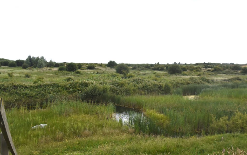
St Andrew’s church at Aller, like Athelney, is on raised ground in the Somerset Levels, suggesting that the church probably would also have been on an island in Alfred’s time. The oldest parts of the current church are 12th century, so the events of 878 must have taken place at a preceding structure. It has been claimed that a font in the church (the more bowl-shaped of the two fonts), recovered from the rectory pond in the nineteenth century, was the one used to baptise Guthrum. The church can be tricky to find. Coming from Langport direction, it is necessary to take a left turn onto the road called Church Path and then turn left where there is a wooden sign for the church. The church also has a small but beautiful King Alfred Window, which is a memorial to the two reigns of King Alfred and Queen Victoria.
The King Alfred stained glass window at St Andrew’s church, Aller, Somerset Levels
It can be speculated as to why Aller, about fifty miles distant from Chippenham, was chosen as the location instead of somewhere closer to Chippenham. Perhaps Alfred did not trust Guthrum and this was deemed to be a safer location, or perhaps Aller was a more significant place then than it seems to us today. It might even be that Alfred knew Aller well if he came here to pray when he had his base at nearby Athelney. It seems likely to me that after obtaining the Viking surrender at (most likely) Chippenham, Alfred simply went back to the Somerset Levels where he may still have had a base, and Guthrum had to go there to “seal the deal”.
I think there is a major clue in the Anglo Saxon Chronicles where we are told that Guthrum came to Alfred at Aller after a period of three weeks. With this time-frame the distance between Chippenham and Aller becomes less of an issue – there was plenty of time to travel. It was a matter of Guthrum having to go to where Alfred was in order to take advantage of an amazingly beneficial deal on the table. In effect it was: “Confirm your permanent submission by becoming baptised and in return we won’t trouble you if you want to settle permanently in the east. Not only this, but you and your men will also receive large amounts of riches” (which were provided subsequently at Wedmore). There is a big difference between the first scenario of the Vikings having effectively seized East Anglia and the later post-878 scenario of the Vikings settling in East Anglia with the approval and blessing of the King of Wessex. In effect, the Viking presence in East Anglia had now become legitimate. East Anglia must have been unstable since 869 when its king (Edmund) had been murdered by the Vikings. Settling it with a converted Guthrum (now called Athelstan after his baptism) probably had benefits for Alfred.
Any hopes that Alfred might have had for peace in East Anglia do not seem to have been realised. In 896 Alfred sent ships to the mouth of the Stour in East Anglia (and therefore somewhere near Harwich) and there were two battles with Viking boats. Alfred’s forces won the first engagement, but the Vikings won the second engagement.
It is by no means certain in my mind that Guthrum was baptised in a church at Aller. In other words, he could have been baptised outside at Aller, because baptism outside in water may have still been taking place, especially for what was a hugely significant moment. If this was the case then there would have been water nearby (Aller is on the Levels). The font in the church that is claimed to be Saxon was re-discovered outside, although it is unknown whether this was used to baptise Guthrum, whether inside or outside of the church.
Aller is the location where Guthrum was baptised, but we must remind ourselves that in The Anglo-Saxon Chronicles we are told that after the Vikings had attacked Chippenham in 878, King Alfred had retreated to morfæstenum, which is a plural. There was more than one stronghold in the marshes, and it is possible that Aller was one of them (and with possibly others on higher ground such as at Burrow Mump).
Aller is only a few miles north-west of Langport, which must have been a significant place in Alfred’s time as it is included in the Burghal Hidage (a list of defended locations), drawn up under his son, King Edward the Elder. Although there is nothing that I could find to specifically connect King Alfred with Langport, it seems likely that he would have been there at some point.
I made a short video at Aller:
There is much more about the travels of King Alfred in my book, including maps and references. To find out more about the book, click or tap the image below.
This post follows on from a more general one about King Alfred and London. Here we specifically look at the town walls. There is a Youtube video at the end of this post.
The walls of London are Roman in origin but they would have been present, although probably much repaired in places, when King Alfred restored London around 886. It seems that prior to then the main population focus of London had shifted after the Romans left to the area that we now know as Aldwych , with the site of the Roman town, approximating to the area that we now call “The City”, becoming very much depopulated. It seems that Alfred’s redevelopment of London led to the area of the walled former Roman town becoming a focus of population again.
I decided to see if it was possible to walk what would have been the perimeter of Alfred’s London. Although the wall is sometimes visible (although, even where visible, subject to much repair or later modification), in most places much imagination is required as the line of the wall runs into modern buildings. Nonetheless, it was a fun thing to do and it certainly helped me to appreciate the shape of the old town.
I started in the Tower Hill area, where there are three places at which the wall can be seen. Travelling anti-clockwise (as in the rest of this post) the first location is what is known as the Postern Gate. This is revealed in a big hole on the same side of the busy Tower Hill arterial road as the Tower of London. From here, if you turn back north and cross the road you will not be able to miss one of the best remaining sections of wall. It is in a pleasant little park and you can walk right up to it on both sides.
A stretch of the original (repaired) Roman wall of London. The Tower of London is in the distance. Ahead (through the buses!) is the site of the Postern Gate, this being the start of the Roman wall.
The next bit of wall is very close indeed, but not immediately obvious. I tried following the line north from the previous bit of wall, proceeding past some modern construction to a point where I could indeed see another stretch of the old wall ahead, although the route was blocked by railings. I found, however, that I could get to the other side by walking to nearby Cooper’s Hill and then down the vehicle entrance to the Grange City Hotel. The wall was then straight in front of me in all its glory. There is a small archway in this wall which allows you to pass through to examine the other side as well. A lovely spot.
A section of the Roman wall of London, located behind the Grange City Hotel, not far from the Tower of London.
The line of the wall then disappears into modern buildings, traversing the railway lines running into Fenchurch Street Station and the enigmatic modern “One America Square.” My research indicated that once the line of the wall had crossed the appropriately named road called “Crosswall”, the next visible section would be to the west of Vine Street. Unfortunately, this was not to be the case. The location where the remains were supposed to be visible was in fact a huge building site. I looked across the site through the couple of viewing windows inserted into the fence but I could see no evidence of any old wall. It must have been hidden from view because it seems that the development once completed will include a display of the preserved Roman wall. The line of the wall then runs through the more recent buildings on the east side of Jury Street, including the Three Tuns pub.
We then arrived at the site of Aldgate. This was where the Roman road to Colchester left London. There is no remaining remnant of the gate above ground because itwas demolished in 1761. We decided to take a break and got some drinks from the pleasant Kahaila cafe (run by a charity) and sat down in the grounds of St Botolph without Aldgate. We then went on to explore up into Dukes Place and Bevis Marks (names of roads). My research indicated that there was some Roman wall visible in an underpass beneath Dukes Place. I have to admit that I could find no underpass, let alone any wall. So we proceeded north-west up Bevis Marks and Camomile Street, where the line of the old wall would be running under the modern buildings on our right, until we arrived at Bishopsgate.
Where the Aldgate, one of the gates through the Roman walls of London, would have once stood.
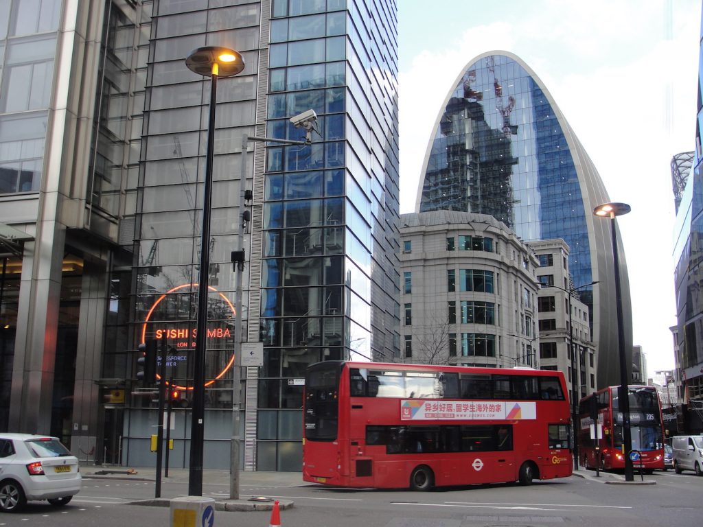
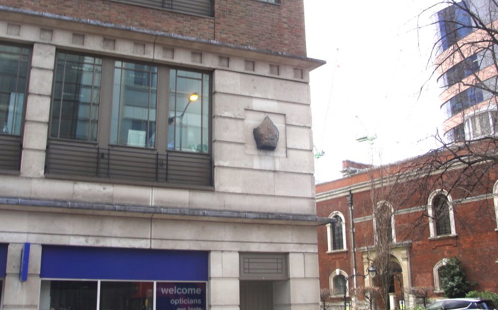
It seems to me that King Alfred would have passed through Bishopsgate at some point. The Roman road called Ermine Street proceeded northwards from this point, and if it was London that Alfred had left from in order to confront the Vikings when they turned up somewhere near Hertford or Ware (Ware is on Ermine Street) in 895, it seems likely that he would have left through Bishopsgate. There are no remains of Bishopsgate above ground because it was demolished in 1760. The site is however marked by a bishop’s mitre above the branch of Boots the Chemists.
Looking west from Bishopsgate up to Camomile Street, which the red London bus is turning in to, and Bevis Marks. One of the gates in the Roman walls of London would have been here (a short distance to my left)The bishop’s mitre, marking the location of the original Bishopsgate, one of the gates in the Roman walls of London.
The line of the old wall now follows the north side of Wormwood Street and the appropriately named (if not accurately, because the line of the wall deviates somewhat from it) thoroughfare called London Wall. As you walk down this road called London Wall, you will see that there is a short stretch of old wall around the back of (north of) the church of All-Hallows on the Wall, but apart from this there are no visible clues until one reaches a stretch of wall in what is called St Alphage’s Garden on one side (under reconstruction when we visited) and Salter’s Garden on the other. Once you get to this point, things are a little more complicated as you have arrived at the site of the Roman fort, which was a separate walled-off square area within the overall outline of the old walls. There is no evidence to support this, but it seems plausible that if there was a protected area within the walls then this may have become King Alfred’s residence in London. The case for this is perhaps slightly strengthened by the limited number of alternative sites. The only other one that I have considered is the site of the Roman praetorium that is largely under Cannon Street station. However, in times of Viking threat I feel that Alfred would have preferred to be in a walled area with easy access to an escape route – which favours the fort rather than the praetorium. Of course it cannot be ruled out that Alfred’s residence was an entirely different building, perhaps wooden, of which no traces remain.
The Roman wall of London at Salter’s Garden. The other side of this wall is St Alphage’s Garden. This is to the north of the road called London Wall. It is a fairly short walk from the Museum of London.
On proceeding west from St Alphage’s Garden, one comes very quickly indded to the site of the former Cripplegate. It strikes me that if Alfred’s residence was indeed at the site of the Roman fort then he would almost certainly have used Cripplegate, simply because it was in the wall of the Roman fort.
Plaque at Cripplegate, where there would have been a gate in the Roman Walls of London. This photo shows one of the ceramic plaques put up in about 1984. Disappointingly, the spirit behind these seems to have withered, as some of these plaques are no longer present.
I found (becauseof railings) that it was necessary to approach the corner of the very north-west section of wall (and therefore also of the fort) from two different directions. This was worth the effort because there are significant stretches of wall visible. The first stretch is immediately south of the church of St Giles Cripplegate and I got there by walking up to the north end of Wood Street and turning left. Just by looking up Wood Street it isn’t immediately obvious that you can do this. The other stretch is accessible from a muddy track leading off from the down access road to the London Wall Underground Car Park. Incidentally, there is some Roman wall preserved at bay 52 of this car park.
The Roman (repaired/replaced) wall of London near the church of St Giles Cripplegate. This is near the Barbican.The Roman wall of London (repaired/replaced) just north of (and facing towards) the down ramp to the London Wall underground car parkThe section of the Roman wall of London at Bay 52 in the London Wall underground car park
Within the area of the fort is the location of St Alban’s church (a rumoured site of King Alfred’s palace), which I write about in another post.
We then come to the west side of the fort (this being an outer wall of the fort meaning that it is also the town wall), which runs alongside Noble Street.
The stretch of the Roman wall of London (repaired/replaced) running alongside Noble Street. Also showing the church of St Anne and St Agnes.
From this point there are no remaining above ground sections of the old town wall. The route, however, is known, and much of it can be walked. Let us proceed. From Noble Street the wall would have headed west (to the north of the church of St Anne and St Agnes), cutting through later buildings and emerging onto the road called St Martins-Le-Grand adjacent to the Lord Raglan pub. Indeed, there is a blue plaque at this point marking the site of the Aldersgate. Like the other gates, there are no remains of Aldersgate (it was demolished in 1761). The route of the wall runs into the buildings on the other side of the road, but mercifully appears again in the lovely Postman’s Park, which lies just behind them.
From here the wall roughly follows the route of the access road/pedestrian walk-through of St Bartholomew’s Hospital, which you will see on the other side of King Edward Street as you emerge from Postman’s Park. Just before this route meets Giltspur Street, the line of the wall turns south and cuts through the buildings to emerge on Newgate Street at, you’ve guessed it, the site of the Newgate. You will probably also guess by now that it has been long demolished and that there are no visible remains above ground. You would be correct. Newgate (along with Ludgate, which is coming up next) would have been a principal gate in the wall for access to and from the west. The west was of course King Alfred’s “heartland”, so I think it quite likely that he would have used these gates.
Blue plaque at the site of Newgate, where there would have been a gate in the walls of London.
The wall then runs south through the Central Criminal Court (Old Bailey) to emerge on Ludgate Hill at the site of the Ludgate (which again is long demolished and with no visible remains above ground). It seems that the wall would have emerged through the excruciatingly named Ye Olde London pub and ran into the currency exchange shop on the other side of Ludgate Hill.
From here it isn’t possible to follow a particular line, but I do recommend wending down through Blackfriars via Carter Lane and Church Entry. The wall ended somewhere down here (it did not run along the riverside), so I recommend a drink in the wonderful Black Friar pub! From here you can follow Upper Thames Street and Lower Thames Street all the way back to the Tower of London, although you will not see any Roman wall, and I find this route very traffic-heavy and polluted.
The Black Friar pub, close to Blackfriars train station and the River Thames.
I put together a video about London’s walls. I apologise for the poor sound quality in places. It was a windy day.
To learn more about my book, click or tap the image below:
It would be great if you could support this project by purchasing a copy.
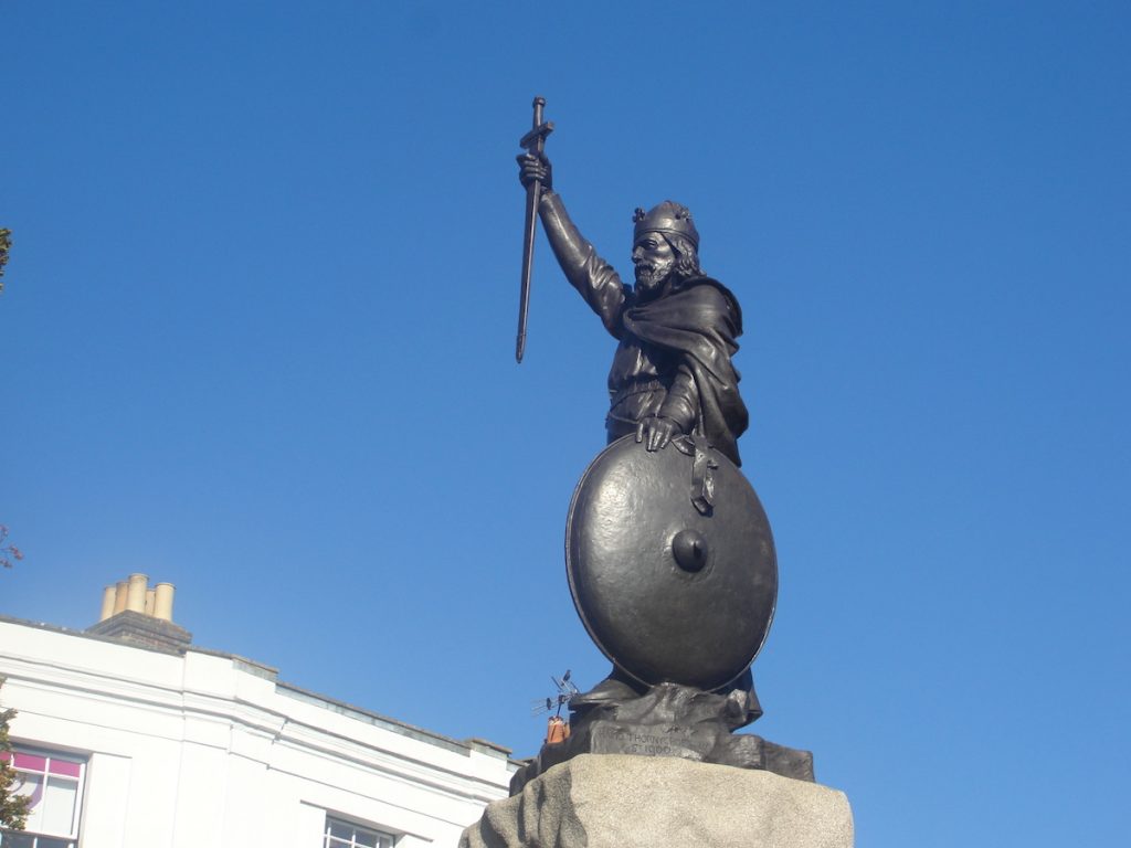
Thorneycroft’s statue of King Alfred the Great in Winchester, Hampshire
Winchester, in Hampshire, is very aware of its associations with King Alfred. But what exactly are these, and what will we uncover if we dig into the detail?
The Anglo-Saxon Chronicles tell us that Winchester had been destroyed by a ship-army in 860, although the attacking forces still lost. Asser (King Alfred’s companion and biographer) tells us that these attackers were Vikings, which perhaps comes as no surprise. However,we do not know where Alfred, who would have been about eleven years old, was at this time.
Although I have seen it implied that Winchester was Alfred’s “capital,” there is little evidence to indicate that Alfred’s court had been centered on a particular location in Wessex. However, we know that Alfred was at Winchester in 896 because he ordered the hanging of captured Vikings after they had run ashore on the Sussex coast. It has also been suggested that Alfred became king in Winchester, although I have seen no evidence to support this.
It seems that there must have been a royal estate at Winchester in Alfred’s time. Alfred does not give any land away at Winchester in his will, although this still allows the possibility that there was a royal estate that was just not owned by him personally, or was somehow under the control of the church instead. Winchester is also listed in the Burghal Hidage, being the account of Alfred’s defended settlements drawn up in the reign of his son, King Edward the Elder. Indeed it shared first place (with Wallingford in Oxfordshire) as the largest settlement in that document. It is indeed possible that the Old Minster (long destroyed – see below) and the royal residence were part of the same complex. It has been claimed that the royal palace was located directly to the west of the Old Minster (and therefore also directly west of the cathedral). I myself once sat on the lawn here (many do) to enjoy my lunch, without having the faintest idea about what might have once been there. As the tourists make a bee-line for the cathedral they may be unwittingly traversing something of competing significance.
The outline of the Old Minster in the lawn adjacent to Winchester Cathedral, HampshireNorth of Winchester Cathedral, and the site of the Old Minster. There isn’t anything left to indicate that the New Minster would have once been here.
Winchester had Roman walls and, although there is some evidence that the area within the walls became depopulated in the early Anglo-Saxon period, it seems that this area may have become repopulated by the time of King Alfred. I have seen it stated that the King’s Gate (or Kingsgate), to the south of the cathedral, had been the entrance through the walls to the royal palace. I have not seen anything to corroborate this, although this is possible as this would have been the closest gate to both the Old Minster and the site claimed to be that of the royal palace. The present gate is a later construction but might be nonetheless on the site or the original gate. It is therefore not beyond the bounds of possibility that King Alfred himself may have walked through here. I strongly recommend the nearby Wykeham Arms as a location in which to consolidate your thoughts. If that is not to your taste then perhaps visit the small church of St Swithun-upon-Kingsgate that is built into the walls above the gate.
King’s Gate from the north. It is possible that there was a gate here in the walls of Winchester in King Alfred’s time, giving access to a royal residence.King’s Gate from the south It is possible that there was a gate here in the walls of Winchester in King Alfred’s time, giving access to a royal residence.
It is generally accepted that what is now called High Street would have been the main street through Winchester in Alfred’s time. Following High Street to the west one comes to the Westgate, which is an impressive structure that includes some Anglo-Saxon fabric. Unfortunately, it isn’t possible to walk a circuit of walls like it is in some other places. However, this did not stop me trying. The most pleasant stretch is to the south-west of the city, where there are actually walls to be seen. These are post-Roman, but generally lie on the route of the Roman walls. Indeed, at one point the wall has been excavated out to show the Roman wall inside. Much of the rest of the route of the wall is covered by buildings, some pleasant and some, in my opinion, quite ugly. There is even a huge multi-story car park on the route.
Winchester Cathedral, Hampshire. From Winkles’ Cathedrals, 1836
At the time of writing the location of the remains of King Alfred is not known. The different religious buildings built at different times can cause confusion in trying to work out the relocations of Alfred’s remains. I therefore hope that what follows will help (alongside the above map). Important to our story are three buildings built close to each other in the centre of Winchester. These buildings, in their order of construction, were the Old Minster, the New Minster, and Winchester Cathedral. Today, the only building that remains is Winchester Cathedral. The Old Minster was just north of the current cathedral, and it is the outline of this building that you can see marked out today on the cathedral lawn. The New Minster was built in the reign of Alfred’s son, King Edward the Elder, to the north of the Old Minster, and he had his father’s remains interred there. However, the New Minster was not consecrated until 901, and Alfred, who had died in 899, was therefore initially interred in the Old Minster while the New Minster was being built. It had been King Alfred’s intention to have the New Minster built in his reign but by the time he died he had only managed to obtain the land. This is why the job of building the New Minster fell to his son. Alfred’s remains were joined in the New Minster by those of his wife Ealhswith when she died in 902. The Old Minster continued to exist alongside the New Minster until the cathedral was consecrated in 1093. The Old Minster was then demolished.
I have provided a short video here:
In 1109 Henry I ordered that the New Minster be moved to land that he had provided at Hyde, which was just outside Winchester at this time. It is possible that the New Minster had suffered from a fire prior to 1109, which might have made the move opportune. Or perhaps Henry I did not want the Saxon New Minster crampimg the style of the gleaming new Norman Winchester Cathedral. The re-located New Minster would then become known as Hyde Abbey. The blog post for Hyde Abbey and the mystery surrounding King Alfred’s remains (Winchester, Part 2) is here.
A perfect place to consolidate one’s thoughts.The Wykeham Arms pub in Winchester, just outside the course of the Roman walls of Winchester
Winchester did not suddenly have greatness thrust upon it at the time of King Alfred. According to version F of the Anglo-Saxon Chronicles, a minster at Winchester was established in 648. In around 660 it became the episcopal seat of the diocese of Wessex, replacing Dorchester-on-Thames. Bede tells us that the remains of the missionary Birinus were transferred here as well while Hedde was bishop, giving us a date range of 649 (around when Birinus died) and 703 (when Hedde died). I argue elsewhere that Sherborne may for a period during King Alfred’s life have been as important, if not more so, than Winchester. However, before and afterwards this would have not been the case, and even during that period Winchester would have remained very important. That it was the seat of the important Swithun is an indication of this.
Winchester Cathedral, Hampshire. From Winkles’ Cathedrals, 1836.
It can be reasonably asked – Why was it that Winchester became so important and not somewhere else? There are no doubt geographical reasons, but I also boldly suggest that it may have been the first settlement of any large (for those times) size made by the Saxons who came to this part of Britain.
There is much more about the travels of King Alfred in my book, including maps and references. Tap or click on the image below to learn more about the book.
In 892 a Viking force of 250 ships sailed from Boulogne to the south coast of Kent and in the same year another Viking force of 80 ships came to the north coast of Kent at a place called Middletune. The Anglo-Saxon Chronicles tell us that Alfred camped with his army between the two Viking armies. In trying to locate Alfred we therefore must try to find the locations that he set up camp between. It seems that the Viking camp in north Kent must have been in the general area of Milton Regis and Sittingbourne, but I could not resist trying to pin it down more specifically.
It is also possible that Alfred himself may have been at this site. The leader of the Vikings that landed on the north coast of Kent was called Hæsten and Alfred must have had some sort of contact with him as it emerges in the Anglo-Saxon Chronicles that a son of Hæsten had become a godson (as had Guthrum in 878) of Alfred. Clearly the history is incomplete, but it is possible that negotiations took place between Alfred and Hæsten at his site at Milton, or at Alfred’s site (another unknown location examined in a future post), or perhaps somewhere else.
Middletune is thought to be Milton Regis, which lies to the north of Sittingbourne, and is now part of that town. Milton was apparently a significant Saxon site. It is said that Queen Seaxburgh of Kent became a nun at the abbey she founded at MIlton, becoming St Seaxburgh, and that her son became king there in 680.
Castle Rough
The earliest reference that I found for this being the site for the Vikings that came to north Kent is in Edward Hasted’s 1797 writings on the history of Kent. The location is just east of Kelmsley, to the west of Milton creek, and close to the evocatively named Saxon Shore Way. It has been suggested that Castle Rough would have been a man-made island. Evidence from limited examination by Sittingbourne and Swale Archaeological Research Group indicated that the lowest parts of the mound contained 13th-14th century pottery, and therefore must have been built after the time of King Alfred. Although this does not rule out this site, because a more extensive examination may have produced more evidence, it does cast doubt upon this being the site of the Viking camp. The location is also moated, which may indicate a date later than the time of King Alfred. Oliver Rackham found that to his knowledge there were no mentions of moats in Anglo-Saxon charters, in place names, or in Domesday. It is therefore possible that moats were a later development. Oliver Rackham also suggested that moats may have become status symbols, which may have been the case here as a moat of this relatively small size would have been largely ineffective against a determined army. It seems that Castle Rough may have been a medieval moated manor, although we cannot rule out that it was something else previously. It was not easy to observe Castle Rough. I pulled over near a gate when driving north along Swale Way, just after crossing over Milton Creek and the Sittingbourne and Kemsley Light Railway. I crossed the road on foot and from this elevated position I fancied that I could pick out Castle Rough. However, I needed my Ordnance Survey map to guide my eye to the approximate location. Update: I have had access to an 1801 Ordnance Survey drawing that shows the feature as distinctly squared as though it was present at that time. There is no indication on this map that it is ancient.
Looking across from the road to the site of Castle Rough, Milton Regis, near Sittingbourne in north Kent, where the Vikings may have set up a camp in 892.
I came across a rumour that the camp was under a canteen at the Kemsley paper mill (close to Castle Rough), but I have been unable to find anything to support this.
The former Kemsley paper mill, near Milton Regis, Sittingbourne, north Kent. On the site of the Viking camp?
Bayford Castle and Bayford Court
The former location of a place called Bayford Castle, on the other side of Milton Creek to Castle Rough, may have been the site of the Viking fortification. However, Hasted, in his 1797 writings on the history of Kent tells us that it was Alfred who built some fortifications against the Vikings on the other side of Milton Creek from Castle Rough at “Baford-castle.” It should be noted that Hasted appears to be an early originator (if not the originator) of the legend that Castle Rough had been the Viking fortification.
The location of Bayford Castle appears on older Ordnance Survey maps with an indication that it was erected in 893. By the time of the 1960 map references to the location had disappeared. There is nothing for the casual visitor to see there now as the location appears to be approximately where there are now industrial units to the east of a karting track. Although evidence is lacking in terms of it being either a Viking or Saxon site, it is at least in a suitable location being near to Milton Creek.
To confuse matters, maps dating to 1590 show that the location of Bayford Castle used to be called Castle Ruffe. I haven’t seen anything to explain why the name of Castle Ruffe disappears from the east side of Milton Creek and then a Castle-ruff (later becoming “Castle Rough”) appears on the other side of the Milton Creek in the 1797 writings of Edward Hasted.
There has been confusion with Bayford Court, which is south of where Bayford Castle appears to have been. This site is located near the centre of Sittingbourne in an industrial area north of Eurolink Way just off Crown Quay Lane. The remains of the Bayford Court moat are marked on the Ordnance Survey map and it was possible to pull over and have a look. However, as described under Castle Rough, moats may have been a later development, and nor is the moat here sufficiently wide to stop a determined army. I therefore feel that although Bayford Court may be an interesting old location, the evidence does not stack up sufficiently for it to be seriously considered as a site for the Viking fortification.
The moat at Bayford Court, Sittingbourne, north Kent. The moat at Bayford Court, Sittingbourne, north Kent.
It seems that although we know that the Viking fortification was at Milton , we cannot locate it precisely. It could, of course, have been located somewhere other than the three locations described above.
There is much more about the travels of King Alfred in my book, including maps and references. Tap or click the image below to learn more about the book.
The writings of a man called Æthelweard tell us that that Alfred besieged London in 886, and another early writer called Henry of Huntingdon suggested that an opportunity had arisen because the Viking presence had been weakened as a result of some having left to join Viking forces on the continent. Although The Anglo-Saxon Chronicles and Asser record Alfred in London at this time, neither source mentions that Alfred had taken London by force. The Chronicles also tell us that in the same year Alfred entrusted London to his son-in-law and ruler of Mercia, Æthelred. London had been a Mercian city and there may have been some resentment after it had been taken over by Wessex, with this being defused by Alfred handing it over to Mercian Æthelred in order to control on behalf of both of them. We know from the Anglo-Saxon Chronicles that London had been under Viking occupation in 871 when they had moved there from Reading. However, the Chronicles also tell us that these Vikings left for Northumbria in 872, and it was perhaps this that subsequently allowed Alfred to start to extend his power to London. Indeed, there is evidence from coins suggesting that London may have been under Alfred’s protection as early as the late 870s.
Where was London?
But what was this London that Alfred was gaining control over? It has been suggested that after Roman control ended the population left the fortified area at the current site of the City of London and went to a place called Lundenwic, approximately 1 mile to the west, perhaps because this provided easier access to a ford at Westminster. The wic element of Lundenwic persists in the modern name Aldwych. It appears that people later moved back to re-use the earlier Roman fortifications (as also appears to have happened at Winchester), and it seems plausible that this move had been triggered by Viking attacks. So, when Alfred took control of London it could well have comprised what is now the City of London and the area around Aldwych, with the two settlements connected by what we now call Fleet Street. There is also evidence of a high status Saxon site at Whitehall, although this seems to have fallen out of use about the same time as Aldwych.
The Queenhithe mosaic on the north bank of the River Thames, London. There would have been a dock here in King Alfred the Great’s time.
It is thought that Alfred restored London after 868 and it has been suggested that the site of the restored Alfredian burgh extended along the north bank of the Thames from near Queenhithe in the west to near Billingsgate in the east, and extending inland by about 300m. It is interesting to note that this area only occupied a small part of the Roman walled area, but in Alfred’s time much space might have been taken up by crops and livestock. Much of this stretch along the river can be walked and for me the most interesting location is Queenhithe, where there are some information boards and one can look out over what would have been a dock in Alfred’s time. It is a great place to stop and think about the Saxon history of London. Queenhithe is named after Matilda, the wife of King Henry I, but the location had previously been called Æthelred’s Hithe, named after king Alfred’s son-in-law.
Queenhithe, on the north bank of the River Thames in London, with the Millennium Bridge and Tate Modern in the distance. There would have been a dock here in King Alfred the Great’s time.
It may be that the administrative centre of London at Alfred’s time was somewhere near Aldermanbury. If this is the case then it seems likely that Alfred would have been there at some point. However, this is based on the presence of the Old English burh in the place name, and it is not known whether this was acquired after the time of King Alfred.
The ward of Aldermanbury, London.
Aldermanbury is immediately to the north-west of the current Guildhall, with Wood Street running north-south through the middle of it. It is possible, based on the 13th century Matthew Paris quoting an 11th century source, that there had been a Saxon royal palace at Aldermanbury near the site of the former church of St Alban on Wood Street. This does not allow us to confirm that it was there when Alfred was alive, but there must have been at least one royal residence and there are few other potential locations within the circuit of London’s walls (another being the site of the former Roman praetorium, the remains of which are largely under Cannon Street station). This church was a victim of the 1940 Blitz and all that remained, with the exception of the tower, was demolished in the 1950s. The tower, now a private residence, still stands in splendid isolation in the middle of Wood Street. if it was still standing, the church would extend eastwards into where the police station is located.
Also perhaps of significance is that this was in a particularly important part of Roman London, being within the outline of the Roman fort, and also very close to the Roman amphitheatre. You may not wish to miss the remains of the amphitheatre, which are located beneath the Guildhall Art Gallery. It is also possible that the walls of the Roman fort were still intact, and this square area at the north-east aspect of the walled city might itself have served as a base (more details on this, with a map, in this post). There is some evidence that there may have been royal palaces at Brentford and Chelsea in the 8th century, but whether these were still in service at the time of King Alfred is not known.
St Alban’s bell tower, Wood Street, London. Inside the outline of the Roman fort. Was there a Saxon royal residence here?
A predecessor to St Paul’s would have been present at or near the site of today’s cathedral, as this had been founded in 604. All Hallows by the Tower shows evidence of Saxon work, so it is possible that a church was also standing there in Alfred’s time.
The north bank of the River Thames, looking east towards London Bridge
Southwark is mentioned in the Burghal Hidage, issued in the reign of Edward the Elder (Alfred’s son) after Alfred’s death, so it seems likely that there was a burgh in place here on the south side of the Thames before Alfred died. Indeed, it is possible that a London Bridge, as a replacement or a repair of the earlier Roman structure, may have been built, perhaps during Alfred’s lifetime, in order to connect the two burghs on either side of the river and to act as a defence against Vikings trying to proceed upstream.
King Alfred may have also been at Chelsea in 892, 898 or 898 (it depends on which reading of a particular charter one is looking at. The one in Corpus Christi, Cambridge has 892. The one from Lambeth Palace has the other dates. The transcription, in Latin, of the Lambeth Palace document is here). I have some concerns about how what seems to be Chelsea is spelt in these documents, which makes me shy away from saying for sure that he was there. It seems to me, however, that it was more likely than not.
It have seen it suggested that Lothbury (a street in the city of London) may have had its name derived from the 7th century King Hlothere of Kent, and that this may indicate that there was some sort of royal function taking place there. However, this does not seem to fit well with evidence that most of the population of London at that time would have been at Lundenwic.
St Paul’s Cathedral, London. From Winkles’ Cathedrals 1836Thames Embankment, London. From Illustrated London News 1856. Looking east. The dome is that of St Paul’s. To the left, back from the river, are the Strand and Aldwych areas.St Paul’s Cathedral, London. From Winkle’s Cathedrals, 1836
I hope that you enjoyed reading about these important events in the history of London. There is much more about the travels of King Alfred in my book, including maps and references. Tap or click the image below to learn more about the book.
The Anglo-Saxon Chronicles refer to Egbert’s Stone (Ecgbryhtes stane) as the place where the armies from Somerset, Wiltshire and part of Hampshire came together to fight alongside Alfred after he had left Athelney in the seventh week after Easter in 878, en route for the important and decisive battle at Ethandun where the Vikings were defeated.
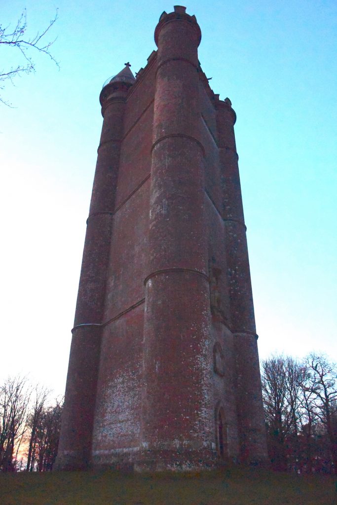
King Alfred’s Tower is frequently suggested as being at or near the site of Egbert’s Stone, and I read some material dating from 1901 that there had been a local tradition that a beacon had been lit here as a signal for the gathering of Alfred’s forces.
King Alfred Tower, Somerset.
This building is a folly, built from 1762 onwards, and is in a lovely location surrounded by woodland on Kingsettle Hill in Somerset. The first thing that struck me about this monument is it’s size. It is huge. Indeed, an american military aeroplane crashed into it in 1944. The second thing that struck me was it’s unusual three-sided shape. I understand the views from the top are excellent but it was closed when I visited. But is this the site of Egbert’s stone? The road that goes past the tower is again the ancient Hard Way (also known as the Harrow Way), with the ancient name surviving at the nearby Hardway Farm. This is the same Hard Way / Harrow Way that crops up in relation to Willoughby Hedge (in a future post) and the Battle of Basing.
The statue of King Alfred the Great, high up on King Alfred’s Tower, Somerset.
From the evidence available, it is, however, difficult to define the location of King Alfred’s Tower as east of, or in the eastern part of, Selwood, which is required to fit the description given by Asser and the Anglo-Saxon Chronicles.
We need to remind ourselves of the size and shape of Selwood. Towards its southern extremity it extended eastwards across to at least Gillingham Forest (Source: Hutchins, History and Antiquities of Dorset, 1774) and further north, in Wiltshire, it extended east at least as far as Warminster. We know this because the following settlements answered at the forest eyre 1187-90: Heytesbury, Knoyle and Westbury. The following villages etc were represented at forest inquisitions: Longbridge Deverill, Sutton Veny, Warminster, and Westbury (source: Victoria County History. Wiltshire Volume IV, 1959)
The location is adjacent to an important ancient route (the Hard Way), but this does not seem enough to determine this to be the spot, or even a candidate, for being the correct location of Egbert’s Stone.
The term “Kingsettle” is also interesting, because there are some woods and a farmhouse approximately 14 miles away, just a short distance north of Shaftesbury, that also have this name. It may be that the name was shared with the location of the tower, or the other way around.
King Alfred’s Tower, Somerset. An unusual three-sided folly
Kilmington Common
Kilmington Common was put forward by a Dr Williams-Freeman in the 1950s . Kilmington Common is the name of the village and it lies about a mile east of Alfred’s Tower. The west-east road and track, named Tower Road and Long Lane respectively, lie on the route of the ancient track called the Hard Way, which is the same Hard Way that goes past King Alfred’s Tower. I parked near where Tower Road meets the village and walked a short distance down the track called Long Lane, partly to appreciate that this was a potential site for Egbert’s Stone and partly for the simple enjoyment of walking on the ancient Hard Way. I looked over to where “the common” is marked on the OS map, but there was little to see apart from crops. Although the case for this location is supported by evidence that tracks ran in other directions near here, it seems difficult to define this location as east of or in the eastern part of Selwood. I therefore consider this to be a less likely location for Egbert’s Stone.
On the Hard Way (also known as the Harrow Way) ancient trackway near Kilmington Common, in Wiltshire. Did King Alfred the Great pass down here after he left Athelney en route to the Battle of Ethandun?
Part three is now available and includes the Deverills in Wiltshire. If you missed part one, it is here.
You can view my video on Egbert’s Stone below:
There is much more about the travels of King Alfred in my book, including maps and references. To learn more about the book, click or tap the image below.
It would be great if you could support this project by purchasing a copy.
The Anglo-Saxon Chronicles refer to Egbert’s Stone (Ecgbryhtes stan) as the place where the armies from Somerset, Wiltshire and part of Hampshire came together to fight alongside Alfred after he had left Athelney in the seventh week after Easter in 878, en route for the important and decisive battle at Ethandun where the Vikings were defeated. It is notable that Dorset is not mentioned. However, Dorset may be an omission because Gaimar indicates that this county was involved.
Tradition has it that King Egbert, Alfred’s grandfather, marked the point where Dorset, Somerset and Wiltshire met with a large stone on the bank of the River Stour. However, it may be unreliable to assume that the counties met at the same location in Egbert’s or Alfred’s time. The woodland then would have extended further south ( as indicated in this book) into today’s Dorset, and because there is some evidence that the edges of the wood were used as boundaries, it is possible that the border could have been further south than it is today. However, I have not seen anything to indicate where any older of boundary might have been. Indeed, it seems that the boundary of Dorset suggested by the Domesday survey of 1086 is more or less unchanged up to Speed’s 1610 map of Dorset, and largely similar to today’s boundaries (allowing for the addition of Christchurch from Hampshire in 1974 and the reversion of Dorset and Devon exclaves to their respective counties in the 19th century). It therefore seems more likely to me that the position of the Dorset border in the north is more or less in the same place as it was in King Alfred’s time.
I drew upon John Peddie’s reference (in this book) to Coombe Street, which is west of Zeals and north of Bourton, as a claimed location. Travelling west, the road crossesthe river where a sign indicates that you have arrived at Pen Selwood. The Stour is narrow at this point, which is unsurprising as its source is at nearby Stourhead. However, I saw no evidence of a significant stone.
The River Stour at Coombe Street near Pen Selwood. No Egbert’s Stone to be seen.
There seems to be an impression locally that a stone at Bullpits Golf Course is Egbert’s Stone. However, I have been told that this is not the case. Nearby Factory Hill crosses the Stour at a point where there was once a mill. When I visited this area it was in the process of being developed for housing. There is a footpath that comes off Kite’s Nest Lane that takes you close to where the three counties meet and water can be seen to your right as you walk up. However, maps show that the exact point at which the three counties meet is very close by but on private land, so I was unable to establish whether there was a stone there, although Phelps in his history of 1836 states that “the three shire-stones” stand in the middle of a pond belonging to Messrs Maggs’ spinning manufactory – which I feel could be the same place. However, the quest was not necessarily to find the stone but to find where Alfred brought his troops together, and if this indeed took place where the three counties now meet, then I was satisfied that I had found the spot.
The White Lion Inn at Bourton, north Dorset. A lovely place to take a break from explorations, and the food and beer are superb.
However, it seems logical that Alfred would have used a meeting point that was strategic in terms of routeways and other factors rather than an obscure location where three administrative boundaries now meet. From the evidence available, it also seems difficult to define this as east of or in the eastern part of Selwood, which is required in order to fit Asser‘s and the Anglo-Saxon Chronicles’ descriptions of the location. For these reasons I consider this site to be a less likely location for Egbert’s Stone.
We need to remind ourselves of the size and shape of Selwood. Towards its southern extremity it extended eastwards across to at least Gillingham Forest (Source: Hutchins, History and Antiquities of Dorset, 1774) and further north, in Wiltshire, it extended east at least as far as Warminster. We know this because the following settlements answered at the forest eyre 1187-90: Heytesbury, Knoyle and Westbury. The following villages etc were represented at forest inquisitions: Longbridge Deverill, Sutton Veny, Warminster, and Westbury (source: Victoria County History. Wiltshire Volume IV, 1959)
It is possible that somebody wished to mark the junction of the three counties with a stone and that this has somehow become tangled up with the record of Alfred’s assembling of troops from different counties. However, the Anglo-Saxon Chronicles do not include Dorset as a county providing forces (although Gaimar does), which further weakens the case for Egbert’s Stone being located here.
Michael Wood, the historian and television presenter, attributes the location of Egbert’s Stone to Penselwood, which is very close to the junction between the three counties, although I don’t know whether that was the reason why he chose it. Pen Selwood is also the supposed location of the Battle of Peonnum, which had been an important victory for the Saxons in 658. However, this was before the time of King Egbert so I cannot see how his name would have become associated with this.
Parts two and three of my Egbert’s Stone posts are now available.
Superb Egbert’s Stone Ale, made by the Copper Street Brewery in Dorchester, Dorset, on the pump in the lovely Royal Standard pub, Upwey, Weymouth.
You can view my video on Egbert’s Stone below:
There is much more about the travels of King Alfred in my book, including maps and references. Tap or click the image below to learn more about the book.
The River Medway at Maidstone, Kent. Looking south from Maidstone Bridge, with the Archbishop’s Palace and All Saints’ Church in the distance to the left
In 892 a Viking force of 250 ships sailed from Boulogne to the south coast of Kent and in the same year another Viking force of 80 ships came to the north coast of Kent.
The Anglo-Saxon Chronicle tells us that the Vikings were at Milton (Milton Regis) to the north and at Appledore to the south, and that Alfred camped with his army between the two raiding armies. Anyone who travels around Kent will soon appreciate the difficulty of simultaneously monitoring these two areas from a single location, because they are quite far apart, so he must have had additional outposts, and perhaps this is what some of the alternative locations (later posts will address these) put forward as Alfred’s base actually were. Indeed, this would fit with the Anglo-Saxon Chronicle telling us that burga (fortresses) were being held.
Milton has now become part of Sittingbourne and was accessible from the Swale via the Milton Creek. Appledore is a lovely village that would have been accessible to the Vikings by following the route of the River Limen (now the Rother) as it would have existed at that time.
Although other possibilities exist, Maidstone has been put forward as a serious contender for the location of Alfred’s base during this Kent emergency.
A crossing of the Medway at Maidstone was developed in saxon times and it has been proposed that the town may have been part of a saxon royal estate with significant ecclesiastical connections.
Maidstone is on the Medway, but it is also at the crossing of a Roman route from Rochester to Hastings (Margary 13) with a possibly ancient track from Ashford to London, now represented by the A20 either side of Maidstone. It has been suggested that in Saxon times Maidstone grew up around this crossing.
Identifying this crossing may help us establish an approximate location of Alfred’s position, if he was based at Maidstone. It appears to be where Week Street, King Street, Gabriel’s Hill and High Street meet. When I visited this location, it was clear that it was near the top of a hill. Such sites are generally strategic.
Looking west down the High Street from the probable site of the origin of Maidstone (at the ancient crossing) in Kent As above, but now looking east towards King Street in Maidstone, Kent.
However, King Alfred lived in the later Saxon period, and by then Maidstone may have developed beyond the vicinity of the junction described above, making it more difficult to define precisely where Alfred might have been.
The location of the former church of St Mary the Virgin may be an important clue . By the 11th century this church was a minster with 17 dependent churches. Some sort of settlement around this site in Alfred’s time would appear to be likely as it would have taken time for a church to build up this level of significance. This church, which was by the Medway, no longer exists, but it is suggested that the site is at the approximate location of, or even beneath, All Saints’ Church, which replaced it in the 1390s.
All Saints’ church, Maidstone, Medway, Kent
The oldest parts of the nearby Archbishop’s Palace date to the 14th century, but the location was likely to have been the site of a manor that we know existed because in 1086 it was being held by the Archbishop of Canterbury. It is therefore possible that there had been a manor here at the time of King Alfred.
The Archbishop’s Palace, Maidstone, Medway, Kent
On visiting this area my attention was drawn to an information board that referred to a track called Knightrider Street going down to the Medway where it could once be forded. I feel that the possibility of being able to easily cross the Medway at this point adds weight to this part of Maidstone, potentially the manor referred to above, being the location for King Alfred’s camp.
Looking down Knightrider Street to the location where there used to be a ford across the River Medway in Maidstone, Kent
I found myself being impressed by the collection of historic buildings, including All Saint’s Church and the Archbishop’s Palace, and it was pleasant to partake in a small circular riverside walk in this area, made possible by the Millenium and Maidstone Bridges. It is worth noting that the latter was designed by Joseph Bazalgette, of Thames Embankment and London sewers fame.
Maidstone is also close to what appears to have been the original Pilgrim’s Way, which was on the route of an ancient trackway. In addition, Maidstone may have offereda direct route to the vicinity of both Milton Regis. In the other direction, there may have been access to the area around Appledore via a route about which we now have no knowledge.
However, Maidstone is much closer to Milton than it is to Appledore, and it is quite a way off a line running between these two places. We therefore possibly run into trouble with the Anglo-Saxon Chronicle having told us that Alfred set up camp between the two raiding armies.
Overall, I feel that Maidstone must have been involved. It seems to have been an important site and it was not far from a Viking base at Milton Regis.
There is much more about the travels of King Alfred in my book, including maps and references. Tap or click the image below to learn more about the book.
Rochester is a lovely and historic city, worth visiting in its own right. However, this city was clearly a target for the Vikings. Rochester had already been sacked by the Vikings in 842, before Alfred was born. However, it was attacked by the Vikings again in 884, but this time King Alfred saw them off.
You may wish to open a map application to help you get the most out of the below. Otherwise just relax and read on.
Where was the Viking camp at Rochester?
The records indicate that on arrival in 884 the Vikings built a fortress around themselves, and we know that this must have been outside of Rochester’s walls because it is recorded in the Anglo-Saxon Chronicles that the inhabitants defended the settlement. Asser tells us that the Viking fortification was at the entrance to the town but, unfortunately for modern-day investigators, there were four entrances, and so the precise location of the Viking fortification has remained unknown. King Alfred later arrived with his forces in 885, and locating the site of the Viking fortification could shed light on where and how Alfred might have engaged with the Vikings and saw that they left. Fortunately, the outline of Rochester’s Roman walls is known. It has been suggested that there would be no Saxon-built stone walls, so the configuration of the walls in 885 should have remained perhaps unchanged since Roman times.
Rochester Bridge over the River Medway (looking north), Kent.
At which gate was the Viking camp?
There had been four gates in the Roman walls. A northern “Bridge Gate” that opened on to the position of the Roman bridge across the River Medway. A north gate, which is more east than north, an east gate that is more south than east, and a south gate that is more west than south. The confusion is explained when one realises that the name seems to indicate the direction in which one could travel after passing through a particular gate, rather than the orientation of the gate itself.
The East Gate
There is evidence that the East Gate was about where the City Wall Wine Bar on High Street is located. On visiting I noticed that the outline of the gate was helpfully marked out with bricks in the pavement and the road, with a metal plaque in the pavement confirming the location.
The outline on the ground of the East Gate in the walls of Rochester, Kent. Easily missed. Had there been a Viking fortification just past the lamp post?
The North Gate
The North Gate appears to be preserved in the current road name of Northgate. It has been suggested that this gate might have just lead to marshy ground. However, there has also been speculation that it may have led to a harbour. Evidence suggests that the Noth Gate would have been approximately where today Northgate meets Corporation Street, being approximately equidistant from Watling Street (which ran along a line close to that of the current High Street) on one side as the cathedral is on the other. This location seems to be consistent with an existing piece of wall that one can see at the back of The Common car park, accessible via Gas House Road and then Acorn Wharf Road. However, the line of bricks in the road at Northgate, outside the Corn Exchange, suggests that at least some person may have thought that the gate may have been not quite as far down Northgate as the junction with Corporation Street. However, I could find no plaque to explain the reason for the bricks embedded into the road at this point.
Rochester, Kent. A line in the road called Northgate which seems to be there to indicate the line of the wall, but might it (and the North Gate) have been a little bit further down somewhere near the junction with Corporation Street towards the right on the photo?
The Bridge/West Gate
The Romans built a bridge at Rochester and a bridge is recorded as present in 960, so a bridge may well have been maintained in the intervening period, including at the time of the Viking attack in 885. This bridge across the Medway is thought to have remained in approximately the same location as today. The location of the gate by the bridge (which I have seen referred to as both Bridge Gate and West Gate) has not been proved although it must have existed in order to allow access to and from the bridge. The gate would most likely have been more or less in line with the bridge. However, the modern bridge is much wider than it has been in the past. Fortunately, the entrance to the old bridge is marked by black lions, which perhaps allows us to speculate that the Bridge Gate would have been at the point where a line drawn from the bridge would have met the town wall.
Rochester, Kent. The north end of High Street, looking north towards the bridge over the River Medway. If it still existed today, the Bridge Gate would surely be in this picture.
The South Gate
It is thought that the South Gate would have been just before where Boley Hill meets St Margaret’s Street, and there is a helpful plaque on a wall that identifies the location. One can wonder whether, if the Viking fortification had been outside this gate, the location would have been where Boley Hill House and Lodge now stand, near the junction of Boley Hill with St Margaret’s Avenue.
The plaque on the wall where the South Gate in the Roman walls of Rochester, Kent, is thought to have been.The site of the South Gate in the Roman walls of Rochester, Kent (plaque on the wall to the right). Looking to the east along Boley Hill
I did not find it possible to exclude any of the entrances as a possible site for the Viking fortification, although I favour the Bridge Gate because the Vikings had a tendency to use waterways and, by blocking the Bridge Gate, they could fend off any support for Alfred from that direction. I was also told by a helpful volunteer at the cathedral that the Bridge Gate currently appears to be the narrow favourite! It seems unlikely that an attacking force would cross the bridge, because such structures restrict the flow of men, making them more vulnerable. If there really had been docks beyond the North Gate it is possible that they could have disembarked there. Alternatively, the Vikings could have disembarked at Chatham and then came up Watling Street to the East Gate of Rochester.
This should provide plenty to think about regarding this important period in the history of Rochester. When you get a chance, pay Rochester a visit, have a look for the sites of the gates of the Roman walls, and see what you think! Rochester Cathedral and Rochester Castle are well worth a visit. You can also see the outline of the Saxon church outlined in the ground partly inside and partly outside of the cathedral.
Rochester Cathedral, Kent, from Winkles’ Cathedrals, 1836.Rochester Cathedral, Kent. The Crypt. From Winkles’ Cathedrals, 1836
There is much more about the travels of King Alfred in my book, including maps and references. Tap or click the image below to learn more about the book.
After Alfred left Athelney, he went via Egbert’s Stone and Iglea to Ethandun where he fought against the Vikings and won. The evidence suggests that after the Vikings had raided Chippenham Wessex had pretty much fallen into their hands. The events leading up to the Battle at Ethandun can therefore be viewed as a reconquest by Alfred for his Kingdom. If Alfred had lost at Ethandun, his loss of Wessex might have become permanent. The stakes were high. However, King Alfred did win this battle, leading to his successful recovery of Wessex.
Paul Kelly, the author of King Alfred: A Man on the Move – climbing Picquet Hill, just south of Edington, Wiltshire
In my opinion, the most likely location that can be pointed out for this battle is the area around the village of Edington in Wiltshire. The following is based on this hypothesis. Please bear in mind that other areas have been suggested (see below). Bratton Camp is also possible because it is close to Edington. We have no proof of where the battle took place but, for the reasons I provide below, places like Edington in Somerset are, in my opinion, far less likely. We need to remind ourselves that it is not an “Edington” that we are seeking but a place called Ethandun, and Edington in Wiltshire fits this.
The route that Alfred would have taken to get from Athelney is contested, largely because the locations of his en-route encampments, at Egbert’s Stone and Iglea, are disputed. If you are interested in the potential routes then you may wish to visit my three posts on Egbert’s Stone (1, 2, 3) and the one on Iglea (here).
Edington
The Anglo-Saxon Chronicles tell us that this battle took place at Eþandun (þ is pronounced “th”), which I refer to as Ethandun. It seems generally accepted that Ethandun is today’s Edington in Wiltshire. Although the identification of Ethandun is most helpful, it still does not allow us to determine the precise location of the battle in that area. My favoured location is the village itself (it seems that there was a royal estate here, and I can’t imagine that the Vikings wouldn’t have taken this) but because there is no proof I explored other options.
Edington Priory church, Wiltshire. It is plausible that the Battle of Ethandun was fought in the vicinity. King Alfred the Great defeated Guthrum and the Vikings in this battle.
Bratton
It has been suggested that Bratton Camp, which is on Bratton Down, had been the Viking base for the Battle of Ethandun. Standing at this Iron-Age hillfort one can appreciate how, coming from the direction of Chippenham to the north (where this particular Viking army appears to have had its base), once the climb up to Bratton Camp had been achieved, they would have had easy access to Salisbury Plain, in order to confront King Alfred and his armies, if indeed they had come that way.
The iron age ramparts at Bratton Camp, Wiltshire. This has sometimes been put forward as the site of the Battle of Ethandun, or perhaps the site of the Viking camp.
East of Westbury, and just a short distance south-west of Edington, Bratton Camp is marked on maps and is easy to find. There is i a figure of a white horse marked out on the hillside, sadly today made out of concrete. I agree with another writer that it seems unusual that two important battles (the other being Ashdown) had been fought in areas with prominent white horses. However, there is no evidence that a white horse would have been present at Bratton Down at or around Alfred’s time. Furthermore, the location of the Battle of Ashdown seems to me to have not been in the vicinity of the white horse at Uffington in Oxfordshire. I decided to avoid the unreliable practice of divining battle sites via horse-led inquiry.
The White Horse above Westbury, Wiltshire.
The parish of Edington extends a fair way south onto Salisbury plain, approximately level with, and just to the west of the deserted village of Imber. On some days the Ministry of Defence allows public access to Imber and some other parts of Salisbury Plain where access is restricted. I went on one of the special services run by Imberbus, where vintage buses go from Warminster train station to permitted locations, including Imber and New Zealand Camp Farm. This was a delightful way of getting around. However, there is much of Salisbury Plain where there is never public access, including south of the village of Edington, and it is perhaps possible that the site of the battle may be beneath an area where access is restricted owing to unexploded ordnance. The best I could do was to explore the roads and paths to the north of the perimeter of the training area. I include the following suggestion because it seemed most interesting and informative in terms of views, and is also within the Edington parish boundary. Just as you approach Edington coming from Bratton there is a lay-by on the right, with a footpath leading north. This fairly steep path takes you up Picquet Hill and over the top of Luccombe Bottom. As you ascend you will pass ancient tumuli and pillow mounds, and the view will open up in a way that allows one to start to understand the landscape of the potential battle site.
Looking north to Picquet Hill (on the right), Wiltshire. Edington is down over the other side.
After their defeat at the battle of Ethandun it is recorded that the Vikings were pursued as far as their fortification. This is generally thought to be Chippenham, but at least one writer has suggested that it could have been Bratton Camp. I can see the temptation to consider Bratton camp as the Viking base, but the evidence for a base at Chippenham is stronger. Of course, Bratton Camp could have been an additional forward base for the battle, but so could have many other places been used as such and it seems possible on Bratton Down to be seduced by the heady combination of a hill-fort, a horse, and wide-ranging views. There is also the matter of maintaining provisions for troops and animals at an elevated position away from water.
A stone and plaque at Bratton Camp, Wiltshire, reminding us that the Battle of Ethandun had taken place in the vicinity.
It has been claimed that that the battle took place at Edington in Somerset. I examine this in my book and find that this is not likely.
Both Asser and the Anglo-Saxon Chronicles describe Alfred as going to Egbert’s Stone after leaving Athelney and, critically, describe this as being east of, or at least in the eastern part of, the great wood of Selwood. This would have taken him to a position about 30 miles east of Athelney. It seems to make little sense that Alfred would make this journey and then travel approximately thirty miles west again to engage the Vikings at Edington in Somerset. Additional evidence against the Somerset Edington comes from the Domesday survey’s recording of the place as Eduuintone, whereas the Wiltshire location is recorded as Edendone, which is closer to Ethandun. Domesday (1086) also tells us that the Wiltshire Edington was under Romsey Abbey and there is a charter dating to 968 showing that King Edgar, Alfred’s grandson, transferred the church and additional land at Edyndon to Romsey Abbey. That this Edyndon is Edington (Wilts) we know from the fact that the document is in Lansdowne MS 422, the contents of which come from the church at Edington. We also know that Alfred left Eþandun to his wife in his will, confirming that the place that went by that name was in royal hands, which fits with King Edgar being able to give the church land away at Edyndon in 968. In 957 King Eadwig had issued a grant from the villa que diciturEðandun. Finally, we have the chronicle of Æthelweard, who mentions Chippenham and Ethandun in practically the same breath.
We have some evidence that Ethandun was a royal estate prior to King Alfred’s reign from a charter (S290) dating to the reign of his father, King Æthelwulf. Please note that for this charter the Electronic Sawyer website (generally superb) has mistakenly placed Halstock in Devon instead of Dorset. Although the location of the place of issue (Æscantun) is no longer known to us, it was then confirmed at Ethandun by the King and a range of bishops, ministers etc. King Alfred is listed as a witness, which would not be possible as he was not yet born. It is thought that the witness list was later transcribed from a later document. For those who wish to go into this matter further the book “Charters of Sherborne” edited by O’Donovan is excellent.
You can view my short video on the Battle of Ethandun below:
There is much more about the travels of King Alfred in my book, including maps and references. To learn more about the book, click or tap the image below: