King Alfred’s Tower. Egbert’s Stone, Part 2

This post on King Alfred’s Tower and Egbert’s Stone is adapted from my book, King Alfred: A Man on the Move, available from Amazon and book shops.

The Anglo-Saxon Chronicles refer to Egbert’s Stone (Ecgbryhtes stane) as the place where the armies from Somerset, Wiltshire and  part of Hampshire came together to fight alongside Alfred  after he had left Athelney in the seventh week after Easter in 878, en route for the important and decisive battle at Ethandun where the Vikings were defeated.


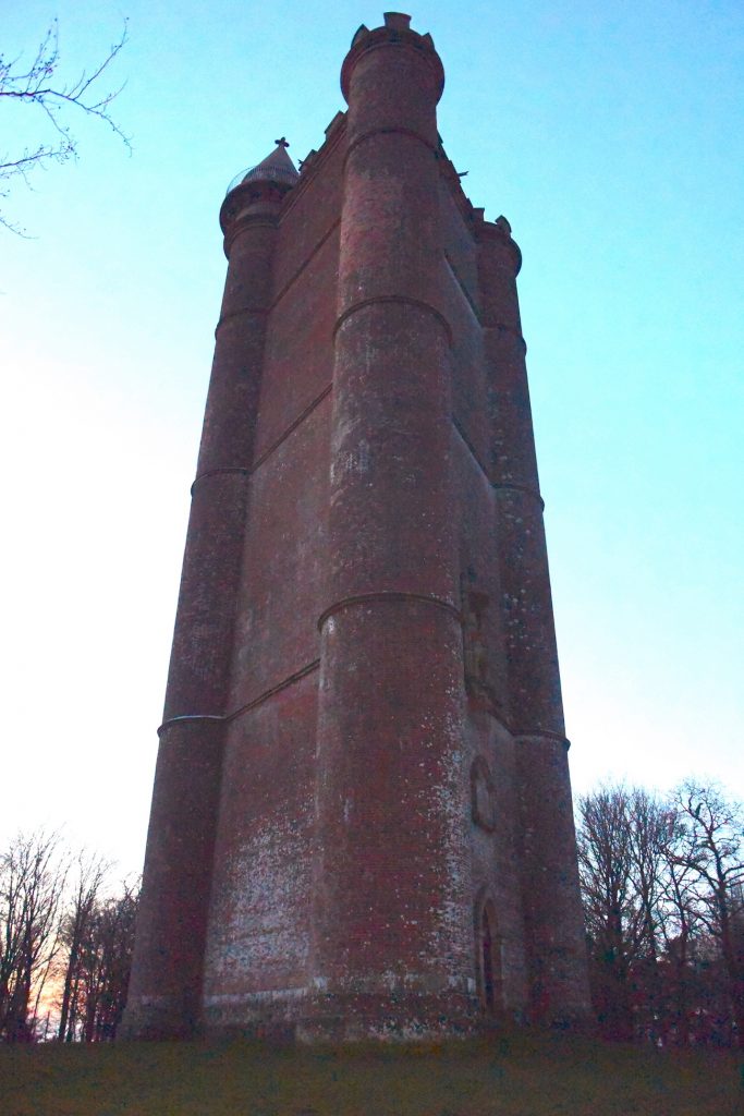
King Alfred’s Tower is frequently suggested as being at or near the site of Egbert’s Stone, and I read some material dating from 1901 that there had been a local tradition that a beacon had been lit here as a signal for the gathering of Alfred’s forces.

King Alfred Tower, Somerset.

This building is a folly, built from 1762 onwards, and is in a lovely location surrounded by woodland on Kingsettle Hill in Somerset. The first thing that struck me about this monument is it’s size. It is huge. Indeed, an american military aeroplane crashed into it in 1944. The second thing that struck me was it’s unusual three-sided shape. I understand the views from the top are excellent but it was closed when I visited. But is this the site of Egbert’s stone?  The road that goes past the tower is again the ancient Hard Way (also known as the Harrow Way), with the ancient name surviving at the nearby Hardway Farm. This is the same Hard Way / Harrow Way that crops up in relation to Willoughby Hedge (in a future post) and the Battle of Basing.

The statue of King Alfred the Great, high up on King Alfred's Tower, Somerset.
The statue of King Alfred the Great, high up on King Alfred’s Tower, Somerset.

From the evidence available, it is, however,  difficult to define the location of King Alfred’s Tower as east of, or in the eastern part of, Selwood, which is required to fit the description given by Asser and the Anglo-Saxon Chronicles.

We need to remind ourselves of the size and shape of Selwood. Towards its southern extremity it extended eastwards across to at least Gillingham Forest (Source: Hutchins, History and Antiquities of Dorset, 1774) and further north, in Wiltshire, it extended east at least as far as Warminster. We know this because the following settlements answered at the forest eyre 1187-90:  Heytesbury, Knoyle and Westbury. The following villages etc were represented at forest inquisitions: Longbridge Deverill, Sutton Veny, Warminster, and Westbury  (source: Victoria County History. Wiltshire Volume IV, 1959)

The location is adjacent to an important ancient route (the Hard Way), but this does not seem enough to determine this to be the spot, or even a candidate, for being the correct location of Egbert’s Stone.

The term “Kingsettle” is also interesting, because there are some woods and a farmhouse approximately 14 miles away, just a short distance north of Shaftesbury, that also have this name.  It may be that the name was  shared with the location of the tower, or the other way around.

King Alfred's Tower, Somerset. An unusual three-sided folly
King Alfred’s Tower, Somerset. An unusual three-sided folly

Kilmington Common

Kilmington Common was put forward by a Dr Williams-Freeman in the 1950s . Kilmington Common is the name of the village and it lies about a mile east of Alfred’s Tower. The west-east road and track, named Tower Road and Long Lane respectively, lie on the route of the ancient track called the Hard Way, which is  the same Hard Way that goes past King Alfred’s Tower. I parked near where Tower Road meets the village and walked a short distance down the track called Long Lane, partly to appreciate that this was a potential site for Egbert’s Stone and partly for the simple enjoyment of walking on the ancient Hard Way. I looked over to where “the common” is marked on the OS map, but there was little to see apart from crops. Although the case for this location is supported by evidence that tracks ran in other directions near here, it seems difficult to define this location as east of or in the eastern part of Selwood. I therefore consider this to be a less likely location for Egbert’s Stone.

On the Hard Way (also known as the Harrow Way) ancient trackway near Kilmington Common, in Wiltshire. Did King Alfred the Great pass down here after he left Athelney en route to the Battle of Ethandun?

Part three is now available and includes the Deverills in Wiltshire. If you missed part one, it is here.

You can view my video on Egbert’s Stone below:

There is much more about the travels of King Alfred in my book, including maps and references. To learn more about the book, click or tap the image below.

In search of Egbert’s Stone. Part 1: The meeting point of Dorset, Wiltshire and Somerset.

This post is adapted from my book, King Alfred: a Man on the Move, available from Amazon.

It would be great if you could support this project by purchasing a copy.

The Anglo-Saxon Chronicles refer to Egbert’s Stone (Ecgbryhtes stan) as the place where the armies from Somerset, Wiltshire and  part of Hampshire came together to fight alongside Alfred  after he had left Athelney in the seventh week after Easter in 878, en route for the important and decisive battle at Ethandun where the Vikings were defeated. It is notable that  Dorset is not mentioned. However, Dorset may be an omission because Gaimar indicates that this county was involved.

Tradition has it that King Egbert, Alfred’s grandfather,  marked the point where Dorset, Somerset and Wiltshire met with a large stone on the bank of the River Stour. However, it may be unreliable to assume that the counties met at the same location in Egbert’s or Alfred’s time. The woodland then would have extended further south ( as indicated in this book) into today’s Dorset, and because there is some evidence that the edges of the wood were used as boundaries, it is possible that the border could have been further south than it is today. However, I have not seen anything to indicate where any older of boundary might have been. Indeed, it seems that the boundary of Dorset suggested by the Domesday survey of 1086 is more or less unchanged up to Speed’s 1610 map of Dorset, and largely similar to today’s boundaries (allowing for the addition of Christchurch from Hampshire in 1974 and the reversion of Dorset and Devon exclaves to their respective counties in the 19th century). It therefore seems more likely to me that the position of the Dorset border in the north is more or less in the same place as it was in King Alfred’s time. 

I drew upon John Peddie’s reference (in this book) to Coombe Street, which is west of Zeals and north of Bourton, as a claimed location. Travelling west, the road crossesthe river where a sign indicates that you have arrived at Pen Selwood. The Stour is narrow at this point, which is unsurprising as its source is at nearby Stourhead. However, I saw no evidence of a significant stone.

The River Stour at Coombe Street near Pen Selwood. No Egbert's Stone to be seen.
The River Stour at Coombe Street near Pen Selwood. No Egbert’s Stone to be seen.

There seems to be an impression locally that a stone at Bullpits Golf Course is Egbert’s Stone. However, I have been told that this is not the case. Nearby Factory Hill crosses the Stour at a point where there was once a mill. When I visited this area it was in the process of being developed for housing. There is a footpath that comes off Kite’s Nest Lane that takes you close to where the three counties meet and water can be seen to your right as you walk up. However, maps show that the exact point at which the three counties meet is very close by but on private land, so I was unable to establish whether there was a stone there, although Phelps in his history of 1836 states that “the three shire-stones” stand in the middle of a pond belonging to Messrs Maggs’ spinning manufactory – which I feel could be the same place. However, the quest was not necessarily to find the stone but to find where Alfred brought his troops together, and if this indeed took place where the three counties now meet, then I was satisfied that I had found the spot. 

The White Lion Inn at Bourton, north Dorset. A lovely place to take a break from explorations, and the food and beer are superb.

However, it seems logical that Alfred would have used a meeting point that was strategic in terms of routeways and other factors rather than an obscure location where three administrative boundaries now meet.  From the evidence available, it also seems difficult to define this as east of or in the eastern part of Selwood, which is required in order to fit Asser‘s and the Anglo-Saxon Chronicles’ descriptions of the location. For these reasons I consider this site to be a less likely location for Egbert’s Stone.

We need to remind ourselves of the size and shape of Selwood. Towards its southern extremity it extended eastwards across to at least Gillingham Forest (Source: Hutchins, History and Antiquities of Dorset, 1774) and further north, in Wiltshire, it extended east at least as far as Warminster. We know this because the following settlements answered at the forest eyre 1187-90:  Heytesbury, Knoyle and Westbury. The following villages etc were represented at forest inquisitions: Longbridge Deverill, Sutton Veny, Warminster, and Westbury  (source: Victoria County History. Wiltshire Volume IV, 1959)

It is possible that somebody wished to mark the junction of the three counties with a stone and that this has somehow become tangled up with the record of Alfred’s assembling of troops from different counties. However, the Anglo-Saxon Chronicles do not include Dorset as a county providing forces (although Gaimar does), which further weakens the case for Egbert’s Stone being located here.

Michael Wood, the historian and television presenter, attributes the location of Egbert’s Stone to Penselwood, which is very close to the junction between the three counties, although I don’t know whether that was the reason why he chose it. Pen Selwood is also the supposed location of the Battle of Peonnum, which had been an important victory for the Saxons in 658. However, this was before the time of King Egbert so I cannot see how his name would have become associated with this.

Parts two and three of my Egbert’s Stone posts are now available.

Superb Egbert's Stone Ale, made by the Copper Street Brewery in Dorchester, Dorset, on the pump in the lovely Royal Standard pub, Upwey, Weymouth.
Superb Egbert’s Stone Ale, made by the Copper Street Brewery in Dorchester, Dorset, on the pump in the lovely Royal Standard pub, Upwey, Weymouth.

You can view my video on Egbert’s Stone below:

There is much more about the travels of King Alfred in my book, including maps and references. Tap or click the image below to learn more about the book.