
This post provides additional material relating to my book: King Alfred, a Man on the Move, available through Amazon and bookshops

This post follows on from a more general one about King Alfred and London. Here we specifically look at the town walls. There is a Youtube video at the end of this post.
The walls of London are Roman in origin but they would have been present, although probably much repaired in places, when King Alfred restored London around 886. It seems that prior to then the main population focus of London had shifted after the Romans left to the area that we now know as Aldwych , with the site of the Roman town, approximating to the area that we now call “The City”, becoming very much depopulated. It seems that Alfred’s redevelopment of London led to the area of the walled former Roman town becoming a focus of population again.
I decided to see if it was possible to walk what would have been the perimeter of Alfred’s London. Although the wall is sometimes visible (although, even where visible, subject to much repair or later modification), in most places much imagination is required as the line of the wall runs into modern buildings. Nonetheless, it was a fun thing to do and it certainly helped me to appreciate the shape of the old town.

I started in the Tower Hill area, where there are three places at which the wall can be seen. Travelling anti-clockwise (as in the rest of this post) the first location is what is known as the Postern Gate. This is revealed in a big hole on the same side of the busy Tower Hill arterial road as the Tower of London. From here, if you turn back north and cross the road you will not be able to miss one of the best remaining sections of wall. It is in a pleasant little park and you can walk right up to it on both sides.

The next bit of wall is very close indeed, but not immediately obvious. I tried following the line north from the previous bit of wall, proceeding past some modern construction to a point where I could indeed see another stretch of the old wall ahead, although the route was blocked by railings. I found, however, that I could get to the other side by walking to nearby Cooper’s Hill and then down the vehicle entrance to the Grange City Hotel. The wall was then straight in front of me in all its glory. There is a small archway in this wall which allows you to pass through to examine the other side as well. A lovely spot.

The line of the wall then disappears into modern buildings, traversing the railway lines running into Fenchurch Street Station and the enigmatic modern “One America Square.” My research indicated that once the line of the wall had crossed the appropriately named road called “Crosswall”, the next visible section would be to the west of Vine Street. Unfortunately, this was not to be the case. The location where the remains were supposed to be visible was in fact a huge building site. I looked across the site through the couple of viewing windows inserted into the fence but I could see no evidence of any old wall. It must have been hidden from view because it seems that the development once completed will include a display of the preserved Roman wall. The line of the wall then runs through the more recent buildings on the east side of Jury Street, including the Three Tuns pub.
We then arrived at the site of Aldgate. This was where the Roman road to Colchester left London. There is no remaining remnant of the gate above ground because itwas demolished in 1761. We decided to take a break and got some drinks from the pleasant Kahaila cafe (run by a charity) and sat down in the grounds of St Botolph without Aldgate. We then went on to explore up into Dukes Place and Bevis Marks (names of roads). My research indicated that there was some Roman wall visible in an underpass beneath Dukes Place. I have to admit that I could find no underpass, let alone any wall. So we proceeded north-west up Bevis Marks and Camomile Street, where the line of the old wall would be running under the modern buildings on our right, until we arrived at Bishopsgate.

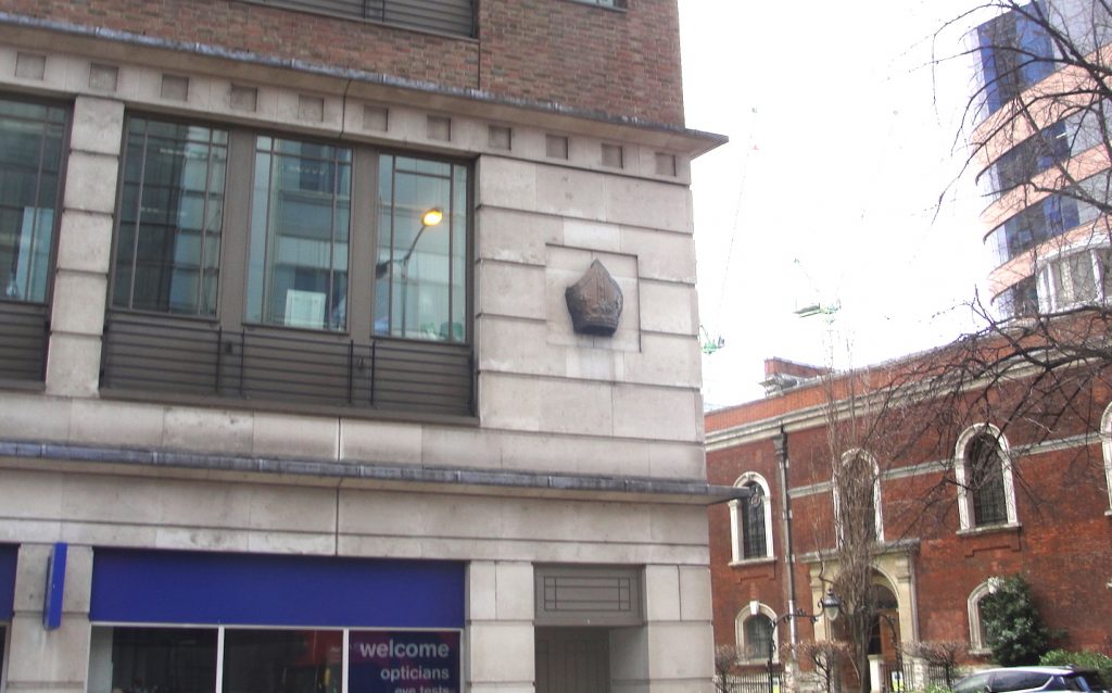
It seems to me that King Alfred would have passed through Bishopsgate at some point. The Roman road called Ermine Street proceeded northwards from this point, and if it was London that Alfred had left from in order to confront the Vikings when they turned up somewhere near Hertford or Ware (Ware is on Ermine Street) in 895, it seems likely that he would have left through Bishopsgate. There are no remains of Bishopsgate above ground because it was demolished in 1760. The site is however marked by a bishop’s mitre above the branch of Boots the Chemists.
The line of the old wall now follows the north side of Wormwood Street and the appropriately named (if not accurately, because the line of the wall deviates somewhat from it) thoroughfare called London Wall. As you walk down this road called London Wall, you will see that there is a short stretch of old wall around the back of (north of) the church of All-Hallows on the Wall, but apart from this there are no visible clues until one reaches a stretch of wall in what is called St Alphage’s Garden on one side (under reconstruction when we visited) and Salter’s Garden on the other. Once you get to this point, things are a little more complicated as you have arrived at the site of the Roman fort, which was a separate walled-off square area within the overall outline of the old walls. There is no evidence to support this, but it seems plausible that if there was a protected area within the walls then this may have become King Alfred’s residence in London. The case for this is perhaps slightly strengthened by the limited number of alternative sites. The only other one that I have considered is the site of the Roman praetorium that is largely under Cannon Street station. However, in times of Viking threat I feel that Alfred would have preferred to be in a walled area with easy access to an escape route – which favours the fort rather than the praetorium. Of course it cannot be ruled out that Alfred’s residence was an entirely different building, perhaps wooden, of which no traces remain.

On proceeding west from St Alphage’s Garden, one comes very quickly indded to the site of the former Cripplegate. It strikes me that if Alfred’s residence was indeed at the site of the Roman fort then he would almost certainly have used Cripplegate, simply because it was in the wall of the Roman fort.

I found (becauseof railings) that it was necessary to approach the corner of the very north-west section of wall (and therefore also of the fort) from two different directions. This was worth the effort because there are significant stretches of wall visible. The first stretch is immediately south of the church of St Giles Cripplegate and I got there by walking up to the north end of Wood Street and turning left. Just by looking up Wood Street it isn’t immediately obvious that you can do this. The other stretch is accessible from a muddy track leading off from the down access road to the London Wall Underground Car Park. Incidentally, there is some Roman wall preserved at bay 52 of this car park.


Within the area of the fort is the location of St Alban’s church (a rumoured site of King Alfred’s palace), which I write about in another post.
We then come to the west side of the fort (this being an outer wall of the fort meaning that it is also the town wall), which runs alongside Noble Street.

From this point there are no remaining above ground sections of the old town wall. The route, however, is known, and much of it can be walked. Let us proceed. From Noble Street the wall would have headed west (to the north of the church of St Anne and St Agnes), cutting through later buildings and emerging onto the road called St Martins-Le-Grand adjacent to the Lord Raglan pub. Indeed, there is a blue plaque at this point marking the site of the Aldersgate. Like the other gates, there are no remains of Aldersgate (it was demolished in 1761). The route of the wall runs into the buildings on the other side of the road, but mercifully appears again in the lovely Postman’s Park, which lies just behind them.
From here the wall roughly follows the route of the access road/pedestrian walk-through of St Bartholomew’s Hospital, which you will see on the other side of King Edward Street as you emerge from Postman’s Park. Just before this route meets Giltspur Street, the line of the wall turns south and cuts through the buildings to emerge on Newgate Street at, you’ve guessed it, the site of the Newgate. You will probably also guess by now that it has been long demolished and that there are no visible remains above ground. You would be correct. Newgate (along with Ludgate, which is coming up next) would have been a principal gate in the wall for access to and from the west. The west was of course King Alfred’s “heartland”, so I think it quite likely that he would have used these gates.

The wall then runs south through the Central Criminal Court (Old Bailey) to emerge on Ludgate Hill at the site of the Ludgate (which again is long demolished and with no visible remains above ground). It seems that the wall would have emerged through the excruciatingly named Ye Olde London pub and ran into the currency exchange shop on the other side of Ludgate Hill.
From here it isn’t possible to follow a particular line, but I do recommend wending down through Blackfriars via Carter Lane and Church Entry. The wall ended somewhere down here (it did not run along the riverside), so I recommend a drink in the wonderful Black Friar pub! From here you can follow Upper Thames Street and Lower Thames Street all the way back to the Tower of London, although you will not see any Roman wall, and I find this route very traffic-heavy and polluted.

I put together a video about London’s walls. I apologise for the poor sound quality in places. It was a windy day.
To learn more about my book, click or tap the image below: