A hot-spot in the Saxon history of Devon

This post provides additional material relating to my book: King Alfred: A Man on the Move, available from Amazon and through bookshops.

I refer to Tiverton, Silverton, Cullompton and Bickleigh as being a mid-Devon hot-spot because I came across evidence relating to King Alfred and his son, King Edward the Elder, for these close-together places. It seems that this area was particularly important in the Saxon history of Devon in and around King Alfred’s time.

King Alfred, in his will, left estates at Mylenburnan, Tiverton (Twyfyrde – refering to two former fords across the rivers Exe and Lowman) and Cullompton to his youngest son Æthelweard. The historians Keynes and Lapidge, in their analysis of King Alfred’s will, favour Silverton as the site of Mylenburnan. In addition, there were four charters issued by King Edward the Elder nearby at a place called Bicanleag, which is believed to be Bickleigh. Although most charters seem to have been challenged at some point as to their authenticity (either in whole or part), it seems to me that the presence of four of them means that it is likely that Bickleigh was a high status location at the time. Bickleigh is not far from the important location of Crediton, which I have written about in an earlier post. Transcripts of the charters can be seen here: S372, S373, S1286, S374. To give an indication of the proximity of the locations, the modern distances by road are: Bickleigh to Tiverton = 4 miles, Bickleigh to Silverton = 4 miles, Bickleigh to Cullompton = 10 miles, Bickleigh to Crediton = 9 miles. This area was clearly significant in the Saxon history of Devon.

I have not seen anything to tell me that Bickleigh was a royal estate at the time of King Alfred. For example it does not appear in King Alfred’s will. However, I wonder whether Bickleigh’s location between Tiverton and Silverton may be more than coincidence.

St Peter's church, Tiverton, Devon
St Peter’s church, Tiverton, Devon

Tiverton

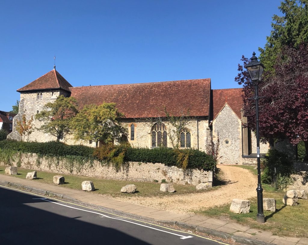
Tiverton was, and remains, an important place in the history of Devon. It is well worth a visit, although most people (myself included) will have passed the town on the A361 dual carriageway to the North Devon coast without realising this. It has a majestic parish church which, although 15th century, includes a re-sited 12th century doorway. It is possible that there might have been an earlier ecclesiastical building on the same site. There are the remains of a 12th century castle adjacent to the church, and the road to the east of the castle and church may have been the market in Saxon times.

View north from the bridge at Tiverton, Devon
Looking north from the bridge at Tiverton, Devon. The likely site of the royal Saxon estate is where St Peter’s church can be seen on the right.

It is interesting to note how the focus of the commercial centre of Tiverton has shifted (to the south) over time, as it also seems to have done at Shaftesbury (where it shifted to the east). It seems sensible that the royal estate would have been where the remains of the castle and the church are located, because if the Normans found a position to be defendable, then the Saxons had probably discovered that fact previously. It isn’t entirely obvious from maps, but when on location it was clear to me that the location is high above the River Exe, making it easier to defend.

Silverton

Silverton is a village just off the main road between Exeter and Tiverton (and south of Bickleigh). Not only did King Alfred leave an estate here in his will, but by Domesday, the hundred that included Cullompton was called Sulfretone (Silverton) Hundred. The parish church here is 15th century (as is the case in many places, there could have been an earlier structure) and, when arriving by car, is not at first easy to find because it is set back from the road. There is a footpath that leads from more or less opposite the shops on Newport Road. Unfortunately when I arrived the church was shut to visitors because of internal scaffolding. It seems that this place was more important in the Saxon history of Devon than is currently popularly realised.

St Mary the Virgin church at Silverton, Devon

Bickleigh

Now to Bickleigh, where it seemed to me that there were two contenders for the location of the estate called Bicanleag from which King Edward the Elder seems to have been issuing charters. The first was the current village centre, focused on St Mary the Virgin church, up a steep hill near Bickleigh Bridge and Bickleigh Mill. The other location was Bickleigh Castle, a manor house and wedding venue. This has been an important location over time, with Queen Henrietta Maria (wife of Charles I) staying here when on the way to Exeter (after which she would flee to France from Falmouth, Cornwall). The main point of interest for this blog post, however, is the chapel, which is thought to go back to Saxon times. Although I have not found proof of this (any help greatly appreciated) it is at least thought to predate the 15th century church of St Mary the Virgin in the village centre, which has a 12th century font (and I was told that the font came from the chapel at Bickleigh Castle). Although it cannot be said with certainty, it seems to me that the most likely location at Bickleigh for the signing of charters is the general area of Bickleigh Castle.

The chapel at Bickleigh Castle, Devon

Cullompton

An estate at Cullompton was also left to Æthelweard in King Alfred’s will. I also found it fascinating that by the time of the Domesday Book (1086), Cullompton was a vill (referred to as Colitone) within the hundred of Silverton. This is revealed in the Liber Exoniensis (searchable here), which contains assessments for Domesday in the South West based on land-owners. This seems to mark Silverton as being a more significant place than Cullompton, whereas today it is the other way around. A word of caution though: Hundred names might sometimes refer to convenient meeting places or local well-known place-names. A case in point would be Culliford Tree in Dorset where, to this day, there is no habitation at this Bronze Age barrow on the crest of a ridge. But where in Cullompton was King Alfred’s estate? Was it the whole of Cullompton as it existed at that time?

St Andrew's church, Cullompton, Devon
St Andrew’s church, Cullompton, Devon

Importantly, the entry for Cullompton in the main Domesday record makes reference to a church. There was therefore a Saxon church at Cullompton and it seems likely that this would have been at the location of the current 15th century St Andrew’s church in the centre of Cullompton. Unfortunately, the church was locked when I visited, which was a shame as I understand it has a great interior and even a King Alfred window. The Saxon church would have probably been associated with the royal estate, so it seems that we can place this somewhere in the general area around the church. It is interesting to note that settlement in Roman times seems to have been around St Andrew’s Hill (with a fort on top), a short distance to the north. Indeed, in various places, Saxon settlement seems to have been at different locations to earlier Roman settlement. Perhaps the most well known is London, with a shift away from what we call The City to the area around Aldwych.

This blog post relating to the Saxon history of Devon is part of a sequel to my book on King Alfred the Great, available from Amazon and bookshops. Click the image to find out more (it takes you to the description on Amazon).

Saxon Hertford, Hertfordshire

This post on King Alfred and Saxon Hertford is adapted and condensed from my book, King Alfred: A Man on the Move, available through Amazon and bookshops.

Those of you who have read the previous post will know that in 895 the Vikings built a fortress on the River Lea about 20 miles north of London and that King Alfred arrived and set up camp nearby. King Alfred then rode up the River Lea to see where the river could be obstructed in order to block the Viking ships in. The river was indeed obstructed and King Alfred started to build a fortification on either side of the river. The Vikings then fled. Hertford and Ware are possible locations for these events and here I shall look a little closer at Hertford.

It is worth pointing out at the start that there is a risk of confusion with the two fortifications that were built in Saxon Hertford in 912-913 by King Alfred’s son, King Edward the Elder. These two fortifications were north and south of the River Lea. However, the first one to be built by Edward the Elder was the northern one and it strikes me as intriguing that the Anglo-Saxon Chronicles describe it as þa norðran burg, which seems to me to translate as the more northerly burg. This in turn suggests that there was already a burg to the south when King Edward the Elder built his first fortification. It is possible that this could have been one of the fortifications that Alfred had built.

As is also the case with Ware, it is uncertain why the Vikings would have gone to Hertford. However, the Anglo-Saxon Chronicles tell us that in 673 a synod took place at Hertford (Heorotford, or Herutford in Bede’s Latin). Indeed, there is a memorial stone associated with this event in Hertford Castle Gardens. There was also a royal mint here as early as the 920s. Although the mint dates to slightly after the time of Alfred, the record of both a synod and a mint suggests that Hertford was an important place in Anglo-Saxon times, perhaps more important than Ware, and it also indicates that Hertford might have been attractive to the Vikings because of its possessions. However, it is possible that the synod took place at the similarly named Hartford in Cambridgeshire instead.

Stone in the grounds of Hertford Castle commemorating the synod that may have taken place there

The River Lea divides just north-east of Mill Bridge to form Hertford’s Folly Island. However, the route of the river through Hertford may not have been the same in 895 and this bifurcation may not have been (as has been suggested) where King Alfred divided the river in order to trap the Viking boats. Nonetheless, the bifurcation can be easily observed near the road called Bull Plain. I have seen reference to the course of the river in Roman times lying to the north -west of its current course, although it may have been in its approximate current location in Alfred’s time because a Viking sword was found in modern times when the River Lea was dredged in the centre of Hertford. Although many Viking weapons are found submerged, it is also possible that the sword found its way into water as the river changed its course. I also saw a reference to remains of Viking ships being found near Hertford and Stanstead Abbots, although I have been unable to corroborate this.

The River Lea dividing near Bull Plain, Hertford.

It was interesting to find on the 1881 Ordnance Survey map an area in Hertford called “Englefield” lying to the east of Bengeo Street and to the north of Warren Park Road. Readers of my book may recall that there was a battle of Englefield near Reading in Berkshire in 871, with the name Englefield probably meaning the land of the Angles. The same map also shows an area called “Daneshill” lying to the south of Warren Park Road, with some nearby land to the north-east being called “Danesbury.” There has also been speculation that the former location of the cricket ground, which used to lie to the east of the pronounced curve of Warren Park Road, could have been a Viking camp. Was there a Viking fortification in this area and did Alfred set up his camp at Englefield? Although we must be cautious of the possibility that antiquarian speculation influenced the place names on the 1881 map, I find the juxtaposition of names potentially referring to Vikings and Anglo-Saxons intriguing. In the absence of definitely-established locations for any Saxon or Viking camps I feel this area must be worth considering. Just a short distance east of these locations lies the 12th century St Leonard’s church. I was told that the current building may have been built on an even older structure that might relate in some way to the Vikings or King Alfred, although I was unable to find any supporting evidence.

St Leonard's church, Hertford
St Leonard’s church, Hertford

The Anglo-Saxon Chronicles tell us that the northerly fortress built by King Edward the Elder in Saxon Hertford was on the other side of the River Beane to the aforementioned Hertford locations of Englefield, Daneshill and Danesbury. The fortress is described as being between the Mimram, the Beane and the Lea (which doesn’t entirely make sense based on current names and geography).

I would like to extend my thanks to the Salisbury Arms in Hertford for their hospitality.

Hyde Abbey, Winchester

This post on Hyde Abbey is adapted and condensed from my book, King Alfred: A Man on the Move, available through Amazon and bookshops. This is my second post on Winchester, the first is located here.

King Alfred was buried at Winchester, in Hampshire, but the location of his remains are unknown. His remains were moved at least twice and the different religious buildings built at different times can cause confusion in trying to work out where these remains went. I refer you to my first post on Winchester for the first two locations of Alfred’s remains, the Old Minster and the New Minster.

In 1109 Henry I ordered that the New Minster be moved to land that he had provided at Hyde, which was then just outside Winchester. It is possible that the New Minster had suffered from a fire prior to 1109, which might have made the move opportune, or perhaps Henry I did not want the Saxon New Minster cramping the style of the gleaming Norman Winchester Cathedral. The re-located New Minster would then become known as Hyde Abbey. In my opinion, the location of this abbey must be one of the most important of the lesser-known sites in British history, and it deserves to be much more famous.

The three stone slabs at Hyde Abbey Gardens, Winchester,marking the location near the high altar where King Alfred, King Edward the Elder (his son) and Ealhswith (his wife) would have been once buried. Their (or some of) their remains may still be present in the vicinity.

Documents indicate that Alfred was transferred to Hyde Abbey in 1110 and that he was interred in front of the altar. Today, Hyde is just north of the city centre and can be easily visited by walking north up Hyde Street, and then turning right into King Alfred Place. This leads to the location of the altar of Hyde Abbey where three stone slabs show where Alfred, his wife and his son were once buried.

Hyde Abbey fifteenth century gateway, Winchester.
Hyde Abbey fifteenth century gateway, Winchester. A reminder of what once stood elsewhere in this part of Winchester.

Hyde Abbey was destroyed in 1539 in Henry VIII’s dissolution of the monasteries. Furthermore, the Annals of Winchester tell us that Hyde Abbey was burnt in 1141, which fits with another record that tells us that the abbey laid “in ruins” after having been set alight in a battle between King Stephen and Matilda in 1141. It seems possible to me that Alfred’s and other important remains could have been relocated in 1141, or prior to the 1539 dissolution. However, the discovery of part of a pelvis (see below) shows that bones from the Anglo-Saxon period remained.

There is a detailed story (for those interested, this is in my book) about how eventually some bones, thought to include those of King Alfred, ended up being interred in the grounds of St Bartholomew’s church, which is located within the footprint of the precinct of Hyde Abbey. However, when these bones were radio-carbon dated, they were found to be more recent than the Anglo-Saxon period. This was the subject of a TV documentary, which you may have seen. To cut a long story short a prison was built on the site in the 1780s and about a decade or so later a Henry Howard made enquiries and was informed by Page (the overseer of the prison construction) about what was found, from which Mellor made a “rough drawing”. The following quote from Howard’s text, which appeared in Archaeologia in 1800, along with his sketch, is most interesting:

“About a [on Howard’s drawing] was also found a stone coffin cased with lead both within and without, and containing some bones and remains of garments. The lead in its decayed state sold for two guineas; the bones were thrown about, and the stone coffin broken into pieces. There were two other coffins, and no more, found in this part, which were also for the sake of the garden, in which they lay, broken and buried as low as the spring.”

I apologise for not putting up an image of his sketch because of copyright etc.

Point a on his drawing seems a plausible location for near the high altar. However, he goes on to say that many more stone coffins were found both to the east (outside the east wall) and the west of this location (in the nave). Clearly, in a situation where bones had been “thrown about”, bones near the altar may not have started off there. The point about the well was taken up by a Mellor who indeed found bones there and sold them to the vicar of St Bartholomew’s, and it seems that these are the bones that ended up collectively buried to the east of that church.

St Bartholomew's church, Hyde, Winchester
St Bartholomew’s church, Hyde, Winchester

Nonetheless, testing was carried out on bones from an excavation at the main site of the abbey undertaken in the 1990s, and a sample from an approximately middle-aged (to us!) male pelvis was dated to 895-1017. Although dating to the correct period, because King Alfred died in 899, it is not possible to say whether this pelvis once belonged to him. King Edward the Elder, who died in 924, was also buried at Hyde Abbey and there is evidence that other individuals may have been too: Æthelweard (a son of Alfred), or Ælfweard (son of King Edward the Elder, although he may have been too young to match the profile of the bone), a monk called Grimbald (although he died quite old) and St Judoc (who, however, died in the 7th century). There may, of course, have been other individuals for which we have no record. Because the bones were found in the vicinity of the high altar (even if it was in back-fill from a Victorian dig) it seems to me not impossible that the bone is from King Alfred, King Edward the Elder, or Æthelweard. Slightly worrying, though, is a record from 1798 that tells us that when a prison was built on the site, bones that were found were “thrown about.” This might mean that what is found near the high altar might not have started off there. Furthermore, would the builders then build over these scattered bones or have them removed? The latter seems more likely. We must remember that Richard III was discovered under a car park in Leicester, so we should perhaps always be ready to be surprised. Richard III, however, died almost 600 years more recently than King Alfred, something that I assume made using a live relative for a DNA comparison (as was done with Richard III) more straight forward. There may have also been less change in use of the land over time in the case or Richard III.

It was hoped that DNA from the pelvis fragment could be matched with those of King Alfred’s grand-daughter, Eadgyth, who was buried at Magdeburg, in Germany. However, although it was thought that it would be possible to extract DNA from the pelvis fragment, it seemed that the remains of Eadgyth were too poorly preserved to attempt a match.

This is a special place to visit, and I always make time to come here whenever I am in Winchester. In fact, this location was one of my main inspirations for writing my book. It is a hugely important location in the history of England.

The for refreshment. There is even a King Alfred pub close to Hyde Abbey Gardens. I had a beer and a meal in here and both were very good.

There is a community group called Hyde 900 that has done a lot of work in relation to the former abbey, and they deserve a mention. Their website also has more information.

Winchester. Part one. The Centre.

This post is adapted from my book, King Alfred: A Man on the Move, available on Amazon.

It would be great if you could support this project by purchasing a copy.

Thorneycroft's statue of King Alfred the Great in Winchester, Hampshire
Thorneycroft’s statue of King Alfred the Great in Winchester, Hampshire

Winchester, in Hampshire, is very aware of its associations with King Alfred. But what exactly are these, and what will we uncover if we dig into the detail?

The Anglo-Saxon Chronicles tell us that Winchester had been destroyed by a ship-army in 860, although the attacking forces still lost. Asser (King Alfred’s companion and biographer) tells us that these attackers were Vikings, which perhaps comes as no surprise. However,we do not know where Alfred, who would have been about eleven years old, was at this time.

A section of a map of Winchester, Hampshire, from my book, King Alfred: A Man on the Move.
A section of a map of Winchester, Hampshire, from my book, King Alfred: A Man on the Move. Contains OS data © Crown copyright and database right (2018).

Although I have seen it implied that Winchester was Alfred’s “capital,” there is little evidence to indicate that Alfred’s court had been centered on a particular location in Wessex. However, we know that Alfred was at Winchester in 896 because he ordered the hanging of captured Vikings after they had run ashore on the Sussex coast. It has also been suggested that Alfred became king in Winchester, although I have seen no evidence to support this.

It seems that there must have been a royal estate at Winchester in Alfred’s time. Alfred does not give any land away at Winchester in his will, although this still allows the possibility that there was a royal estate that was just not owned by him personally, or was somehow under the control of the church instead. Winchester is also listed in the Burghal Hidage, being the account of Alfred’s defended settlements drawn up in the reign of his son, King Edward the Elder. Indeed it shared first place (with Wallingford in Oxfordshire) as the largest settlement in that document. It is indeed possible that the Old Minster (long destroyed – see below)  and the royal residence were part of the same complex. It has been claimed that the royal palace was located directly to the west of the Old Minster (and therefore also directly west of the cathedral). I myself once sat on the lawn here (many do) to enjoy my lunch, without having the faintest idea about what might have once been there. As the tourists make a bee-line for the cathedral they may be unwittingly traversing something of competing significance.

The outline of the Old Minster in the lawn adjacent to Winchester Cathedral, Hampshire
North of Winchester Cathedral, and the site of the Old Minster. There isn't anything left to indicate that the New Minster would have once been here.
North of Winchester Cathedral, and the site of the Old Minster. There isn’t anything left to indicate that the New Minster would have once been here.

Winchester had Roman walls and, although there is some evidence that the area within the walls became depopulated in the early Anglo-Saxon period, it seems that this area may have become repopulated by the time of King Alfred. I have seen it stated that the King’s Gate (or Kingsgate), to the south of the cathedral, had been the entrance through the walls to the royal palace. I have not seen anything to corroborate this, although this is possible as this would have been the closest gate to both the Old Minster and the site claimed to be that of the royal palace. The present gate is a later construction but might be nonetheless on the site or the original gate. It is therefore not beyond the bounds of possibility that King Alfred himself may have walked through here. I strongly recommend the nearby Wykeham Arms as a location in which to consolidate your thoughts. If that is not to your taste then perhaps visit the small church of St Swithun-upon-Kingsgate that is built into the walls above the gate.

King's Gate from the north. It is possible that there was a gate here in the walls of Winchester in King Alfred's time, giving access to a royal residence.
King’s Gate from the north. It is possible that there was a gate here in the walls of Winchester in King Alfred’s time, giving access to a royal residence.
King's Gate from the south It is possible that there was a gate here in the walls of Winchester in King Alfred's time, giving access to a royal residence.
King’s Gate from the south It is possible that there was a gate here in the walls of Winchester in King Alfred’s time, giving access to a royal residence.

It is generally accepted that what is now called High Street would have been the main street through Winchester in Alfred’s time. Following High Street to the west one comes to the Westgate, which is an impressive structure that includes some Anglo-Saxon fabric. Unfortunately, it isn’t possible to walk a circuit of walls like it is in some other places. However, this did not stop me trying. The most pleasant stretch is to the south-west of the city, where there are actually walls to be seen. These are post-Roman, but generally lie on the route of the Roman walls. Indeed, at one point the wall has been excavated out to show the Roman wall inside. Much of the rest of the route of the wall is covered by buildings, some pleasant and some, in my opinion, quite ugly. There is even a huge multi-story car park on the route.

Winchester Cathedral, Hampshire
Winchester Cathedral, Hampshire. From Winkles’ Cathedrals, 1836

At the time of writing the location of the remains of King Alfred is not known. The different religious buildings built at different times can cause confusion in trying to work out the relocations of Alfred’s remains. I therefore hope that what follows will help (alongside the above map). Important to our story are three buildings built close to each other in the centre of Winchester. These buildings, in their order of construction, were the Old Minster, the New Minster, and Winchester Cathedral. Today, the only building that remains is Winchester Cathedral. The Old Minster was just north of the current cathedral, and it is the outline of this building that you can see marked out today on the cathedral lawn. The New Minster was built in the reign of Alfred’s son, King Edward the Elder, to the north of the Old Minster, and he had his father’s remains interred there. However, the New Minster was not consecrated until 901, and Alfred, who had died in 899, was therefore initially interred in the Old Minster while the New Minster was being built. It had been King Alfred’s intention to have the New Minster built in his reign but by the time he died he had only managed to obtain the land. This is why the job of building the New Minster fell to his son. Alfred’s remains were joined in the New Minster by those of his wife Ealhswith when she died in 902. The Old Minster continued to exist alongside the New Minster until the cathedral was consecrated in 1093. The Old Minster was then demolished.

I have provided a short video here:

In 1109 Henry I ordered that the New Minster be moved to land that he had provided at Hyde, which was just outside Winchester at this time. It is possible that the New Minster had suffered from a fire prior to 1109, which might have made the move opportune. Or perhaps Henry I did not want the Saxon New Minster crampimg the style of the gleaming new Norman Winchester Cathedral. The re-located New Minster would then become known as Hyde Abbey. The blog post for Hyde Abbey and the mystery surrounding King Alfred’s remains (Winchester, Part 2) is here.

The Wykeham Arms pub in Winchester, just outside the course of the Roman walls of Winchester
A perfect place to consolidate one’s thoughts.The Wykeham Arms pub in Winchester, just outside the course of the Roman walls of Winchester

Winchester did not suddenly have greatness thrust upon it at the time of King Alfred. According to version F of the Anglo-Saxon Chronicles, a minster at Winchester was established in 648. In around 660 it became the episcopal seat of the diocese of Wessex, replacing Dorchester-on-Thames. Bede tells us that the remains of the missionary Birinus were transferred here as well while Hedde was bishop, giving us a date range of 649 (around when Birinus died) and 703 (when Hedde died). I argue elsewhere that Sherborne may for a period during King Alfred’s life have been as important, if not more so, than Winchester. However, before and afterwards this would have not been the case, and even during that period Winchester would have remained very important. That it was the seat of the important Swithun is an indication of this.

Winchester Cathedral, Hampshire
Winchester Cathedral, Hampshire. From Winkles’ Cathedrals, 1836.

It can be reasonably asked – Why was it that Winchester became so important and not somewhere else? There are no doubt geographical reasons, but I also boldly suggest that it may have been the first settlement of any large (for those times) size made by the Saxons who came to this part of Britain.

There is much more about the travels of King Alfred in my book, including maps and references. Tap or click on the image below to learn more about the book.